Modoc County

Modoc County
The River Center in Alturas offers a wealth of programs and information about the surrounding area, including the Pit River Watershed, Modoc County and Siskiyou County in California,  Lake County and Klamath County in Oregon.  The center is now housed in the Modoc Historical Museum, 600 S Main St, which is  wheelchair accessible.  Call 530-233-4314 ext. 115 for hours and other information.
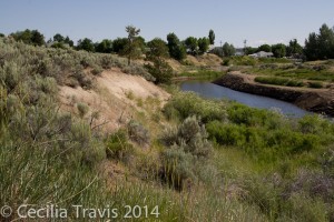
HikerwithcaneThere is an easy walking path along the Pitt River, but  is very soft sand and probably would be difficult for a wheelchair.

Easy path along Pitt River, Alturas CA
Pitt River, Alturas
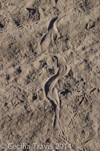
Snake and quail trails in soft sand
Snake and quail trails in soft sand by Pitt River

Patrick’s Point State Park

Patrick’s Point State Park
Patrick’s Point State Park has three short accessible trails.  The 640 acre park is 30 miles north of Eureka, California and lies on a forested promontory overlooking the Pacific Ocean.  There are accessible campsites.  Patrick’s Point SP is in redwood country and you will find “Forests of spruce, hemlock, pine, fir and red alder stretch over an ocean headland with wildflower-filled meadows.”   On our very short visit we just walked along the road and enjoyed the marvelous scenery.   Accessibility   Phone 707-677-3570  Here is the park’s website.   

Wheelchair AccessibleCeremonial Rock/Sumeg Village Trail  0.73  goes through a spruce forest, passing near to the Native Plant Garden,Sumeg Village, and Ceremonial Rock.
Wheelchair AccessibleRim/Campfire Center Trail  0.87 mile is a hike along the coastal bluff with multiple views of the ocean.
Wheelchair AccessiblePatrick’s Point Overlook Trail 0.07 a spur trail on top of coastal bluff with 180° view of the ocean.

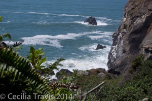
View from easy trail at Patrick's Point State Park, California
View from easy trail at Patrick’s Point State Park, California
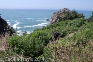
Easy trail at Patrick's Point State Park, California
Easy trail at Patrick’s Point State Park, California

Trinidad State Beach

Trinidad State Beach
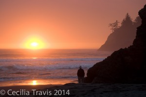
Trinidad State Beach has a short trail through forest which is rated “generally accessible”.  What we liked was that you can get to the water from the parking lot without having to go down steep stairs.  The photo below was taken a short distance from the parking lot.   The beach is 19 miles north of Eureka, CA, just off Highway 101.  Park hours are from sunrise to sunset.  Phone 707-677-3570.  Here is their website.    Accessibility

?  Trinidad State Beach and College Cove 2 mile loop with some steep sections. Although AllTrails describes it as suitable for all skill levels, some of their reviewer say parts are quite steep.

Sunset at easily accessed Trinidad Beach, California
Sunset at Trinidad Beach, California

Henry Cowell Redwoods State Park

Henry Cowell Redwoods State Park
Henry Cowell Redwoods State Park, in the Santa Cruz Mountains of California has a lovely wheelchair accessible trail and an easy loop walking trail.   The park is most famous for the 40-acre grove of towering old-growth redwood trees and lies on 4,650 acres of forested and open land.
The visitors center has a loaner wheelchair, but you had better call in advance (831-335-4598) as they are short staffed and sometimes the center is unpredictably closed.   Here is their websiteTrail descriptions
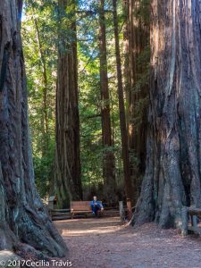
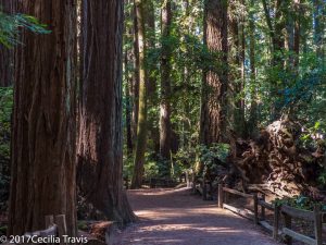
Wheelchair AccessibleRedwood Grove Trail 0.8 mile loop –  A great horned owl’s hooting added to the pleasure of this lovely trail among giant redwood trees.  Thank you Mark Hehir, for the suggestion.

Bench on wheelchair accessible ADA Redwood Grove Trail, Henry Cowell State Park, CA
Bench on wheelchair accessible Redwood Grove Trail, Henry Cowell State Park, CA
Wheelchair accessible ADA Redwood Grove Trail, Henry Cowell State Park, CA
Wheelchair accessible Redwood Grove Trail, Henry Cowell State Park, CA
 Meadow-River Loop  1 mile loop, described as “gentle”.   Take the Meadow Trail just off Highway 9 to the Nature Store and return on the River Trail.

Plumas National Forest

Plumas National Forest
The Plumas National Forest northeast of Chico, California has many easy trails and a couple of accessible ones.  However, remember that a trail designated as “easy” may not be easy enough for you.  Visitors to the Plumas National Forest enjoy its “many streams and lakes, beautiful deep canyons, rich mountain valleys, meadows, and lofty peaks.”   The Forest is divided into three Ranger Districts.  Call before heading out to determine trail conditions.
Phone 530-283-2050  Here is the Forest website.

Beckwourth Ranger District  phone 530-836-2575  Trail Descriptions.
Fern Falls Overlook  0.1mile On the Gold Lake Hwy. The trail crosses Gray Eagle Creek and leads to a scenic overlook near Fern Falls.
Grassy Lake Trail 0.8 mile  leads past Grassy Lake and crosses Gray Eagle Creek.
Wheelchair AccessibleFrazier Falls 0.5 mile on the old Gold Lake road.  A paved trail leads to a fenced scenic overlook of the 176 foot tall Frazier Falls. ” Individuals in wheelchairs may need assistance. Wheelchair rating difficult”
Red Fir Nature Trail 0.5 mile on the Mills Peak Lookout road.  Signed trail interpreting the ecosystem within a red fir stand.
Wheelchair Accessible Big Cove Enabler 0.2 miles  Leads from Big Cove Campground to the lake.

Feather River Ranger District  Phone (530) 534-6500  Trail Descriptions
Big Bald Rock – 0.5 mile one way.  Near the town of Berry Creek.

Little North Fork 2 miles one way.  After the first 2 miles the trail becomes steep.  15 miles northeast of Brush Creek Work Center. The trail follows the Little North Fork River north towards the historic Robinson Mine but the trail no longer actually reaches Robinson Mine.

Mt. Hough Ranger District   Trail Descriptions

 Yellow Creek Trail 1.4 miles  Near the Ely Stamp Mill rest area, across from Belden, “…an enjoyable day hike that ends in a box canyon.”

Know more about Plumas National Forest?
Have you visited this location and know of more accessible or easy trails?  Is any of the information given here incorrect?  If so, please contact me using the form to the left and let me know what should be changed or added so I can update this post.

Mendocino Nat’l Forest

Mendocino National Forest
The Mendocino National Forest has a couple of accessible trails at Chico Seed Orchard. The Orchard produces plants for a wide variety of projects ranging from reforestation and mine reclamation to biological, chemical, and clinical research on anti-cancer drugs derived from plants.  The Mendocino is uncrossed by paved roads.  Its elevation goes from 750 feet in the Grindstone Creek Canyon in the Sacramento Valley foothills on the Forest’s eastern edge to the 8092 feet of South Yolla Bolly Mountain in the northern part of the Forest.
Accessible Recreation Possibilities    Phone 530-934-3316   Here is their website.

Chico Seed Orchard  
Wheelchair Accessible
Comanche Trail  1 mile loop  in “The 3/4 mile hard surface trail winds through mixed stands of mature trees with walk bridges crossing small stream beds.”
Wheelchair AccessibleSelf-guiding nature trail: 1 mile loop “meanders through a unique botanical area in Edgar Slough which has remnants of exotic species that were planted when this was a Plant Introduction Center.

Know more about Mendocino National Forest?
Have you visited this location and know of more accessible or easy trails?  Is any of the information given here incorrect?  If so, please contact me using the form to the left and let me know what should be changed or added so I can update this post.

San Bernardino Nat’l Forest

San Bernardino National Forest
The San Bernardino National Forest in Southern California has many easy and a few accessible trails.  The  823,816 acre Forest includes five wilderness areas. There are district Ranger Offices at Fawnskin, Idyllwild, and Lytle Creek.   Baron Flats and Mill Creek have Visitor Centers.  Elevation ranges from 2,000′ to 11,499′.
Here is the Forest website.    Headquarters are in San Bernardino, phone  909-382-2600   Visitors Guide   Accessibility

San Jacinto Ranger District, Idyllwild   phone 909-382-2921
Ernie Maxwell Scenic Trail – 2.6 mile trail leaves from Humber Park. The trail starts at 6100 ft. elevation and crosses streams as it descends 600 ft.  It is rated easy, but may not be easy for you.  Call ahead to learn more.
Chaparral Neighborhood Trail 0.5 mile self guided nature trail.  Said to be easy, but check with the Ranger Station first.

Front Country Ranger District, Lytle Creek  phone 909-382-2851
Wheelchair AccessibleNative Plant Garden  paved walkways through different local plant communities.  No ADA rating, but this garden right behind the ranger station sounds likely.
Rio Monte Trail  2.5  miles “easy walk”  Starts at Barton Flats Visitor Center.  Check ahead 909-794-4861 to determine if this is easy enough for you.
Big Falls Trail  0.3 miles “easy walk”  The trail goes to the highest waterfall in Southern California.

Mountain Top Ranger District, Fawnskin  phone 909-382-2790
Lake Arrowhead area
Seeley Creek Trail  1 mile described as “gentle”.  Trail crossed the creek and ends at a waterfall.
Heaps Peak Arboretum Trail  0.7  mile loop  a self guided nature tour that is “easy for all ages”.
Wheelchair AccessibleTrail of the Phoenix  0.5 mile loop “designed and maintained to accommodate the needs of the visually and physically disabled.”
Big Bear Valley
Wheelchair AccessibleAlpine Pedal Path  2.5 miles one way asphalt path  “connects the Big Bear Discovery Center with the Cougar Crest Trailhead and a pathway along the North shore of Big Bear Lake”    “…this gentle trail has some magnificent views of the lake.”
Nature Discovery Trail 0.5 mile loop through the forest behind the Big Bear Discovery Center.
Woodland Trail  1.5 mile loop self guided interpretive trail

Champion Lodgepole Pine Trail 0.3 mile one way along a small stream, ending at one of the largest known Lodgepole pines in California.  You can continue another 0.4 mile on the Bluff Mesa Trail which is a “leisurely walk” through stands of Jeffrey Pine.

Know more about San Bernardino National Forest?
Have you visited this location and know of more accessible or easy trails?  Is any of the information given here incorrect?  If so, please contact me using the form to the left and let me know what should be changed or added so I can update this post.

Yosemite National Park

Yosemite National Park
The 1,200 square miles of  Yosemite National Park include impressive waterfalls,  deep valleys, grand meadows, ancient giant sequoias, and a vast wilderness area.
Here is the Park website.   Accessibility Guide  Phone  Park Headquarters  209-372-0200   Accessibility Coordinator 209‐379‐1035
Yosemite Valley     Here is a video of easy trails.
Wheelchair AccessibleLower Yosemite Falls Trail 1 mile paved  “Consider walking the loop in a clockwise direction for best views of Yosemite Falls. This eastern portion of this loop trail is wheelchair accessible (when not covered in ice or snow).”
Bridalveil Fall Trail 0.5 mile paved  The trail is considered too steep for wheelchairs.
Mirror Lake Trail 1 mile paved.  Be sure to go in the spring when there is a lake and not just a meadow.
Cook’s Meadow Loop  1 mile  “…short, easy walk offers stunning views of Yosemite Falls, Half Dome, Glacier Point, and Sentinel Rock.”
Wawona
Wawona Meadow Loop  3.5 miles

White Wolf
?  Lukens Lake from Tioga Road  1.6 miles round trip.  “The trail winds through a mixed conifer forest, then over a saddle and down to a small mountain lake surrounded by a meadow.”    Although this trail is rated “easy” you had better call first to learn about possible obstacles.
Tuolumne Meadows
Soda Springs and Parsons Lodge 1.5 miles   Described in trailmob.com  as “a great choice for hikers traveling with small children. ”

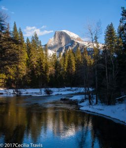
Half Dome seen from accessible road, Yosemite National Park, California
Half Dome, seen from accessible Sentinel Bridge, Yosemite National Park, CA

Golden Gate National Rec. Area

Golden Gate National Recreation Area
The park has many interesting sites to visit including Alcatraz Island, Muir Woods National Monument, Fort Point National Historic Site, the Marin Headlands,
Here is their website and their page regarding accessibility.    
Map and Brochure Phone 415-561-4700

Wheelchair Accessible

Muir Woods has an accessible boardwalk for several hundred feet to Founders Grove. “…past the boardwalk you will encounter an asphalt trail which is usable; however, it contains potholes and severe cracks due to heaving tree roots. As funding and resources allow, we will continue to replace the existing asphalt with an accessible raised boardwalk.”  Muir Woods Brochure is available in Braille.  Accessibility at Muir Woods.

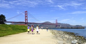
Wheelchair AccessibleThe photo is courtesy of Mark Hehir, who writes that San Francisco’s Crissy Field has “several handicap parking spots, and you have a wonderful view of the Golden Gate Bridge, and of Alcatraz Island.”

Wheelchair accessible path by Golden Gate Bridge from Crissy Field, San Francisco, CA
Wheelchair accessible path by Golden Gate Bridge from Crissy Field, San Francisco, CA ©Mark Hehir 2014