Lee Metcalf National Wildlife Refuge
“There are 2 ½ miles of nature trails in the Refuge’s Wildlife Viewing Area. The trails meander through meadows and river bottom woodlands along the Bitterroot River. The refuge is along the Glacial Lake Missoula National Geologic Trail and along two National Historic Trails – the Lewis and Clark Trail and the Nez Pierce Trail. ”
Here is the Refuge website. Description from OhRanger! Phone 406-777-5552
The 2 ½ miles of nature trails in the Refuge’s Wildlife Viewing Area are described as easy and flat.
![]() Kenai Nature Trail 1.25 mile the first 0.5 is mile paved and wheelchair-accessible.
Kenai Nature Trail 1.25 mile the first 0.5 is mile paved and wheelchair-accessible.
Wildfowl Lane is a Ravalli County road that travels almost 3 miles through the southern half of the refuge.
Category: Montana Federal
Flathead National Forest
Flathead National Forest
“The Flathead National Forest contains three wilderness areas, two ski areas, impressive mountain ranges, lakes, wild and scenic rivers, campgrounds, picnic areas, and cabins.”
Here is the Forest website. Supervisor’s Office 406-758-5208
Tally Lake Ranger District phone 406-758-5204
Glacier View Ranger District, Hungry Horse Ranger District, and
Spotted Bear Ranger District (winter) 406-387-3800
Spotted Bear Ranger District (Summer) 406-758-5376 (summer)
Swan Lake Ranger District 406-837-7500
Here is a brochure listing a few trails in the Forest with “gentle to moderate” slopes. The following “comply with Forest Service Trail Accessibility Guidelines”
![]() Round Meadow Trail 1 – 13 miles
Round Meadow Trail 1 – 13 miles
![]() Tally Lake Trail 0.4 miles
Tally Lake Trail 0.4 miles
![]() Krause Basin Interpretive Trail 0.3 mile
Krause Basin Interpretive Trail 0.3 mile
Bighorn Canyon National Recreation Area
Bighorn Canyon National Recreation Area
Bighorn Canyon NRA’s over 120,000 acres offers an “astounding diversity in ecosystems, wildlife, and more than 10,000 years of human history to explore.”
Hiking Guide Map This recreation area bridges Montana and Wyoming.
Driving directions from Montana and Wyoming Links to Trail Descriptions Here is their website. Phone 406-666-2412 or 307-548-5406 Accessibility
![]() Two Eagles Interpretive Trail 0.25 miles round trip
Two Eagles Interpretive Trail 0.25 miles round trip
![]() Bighorn Headgate Trail rated as an easy gravel path of 0.1 mile round trip to “quiet picnic area”.
Bighorn Headgate Trail rated as an easy gravel path of 0.1 mile round trip to “quiet picnic area”.
![]() Lockhart Ranch Trail consists of a choice of loops, one 0.5 miles, the other 2 miles. Both are old dirt roads.
Lockhart Ranch Trail consists of a choice of loops, one 0.5 miles, the other 2 miles. Both are old dirt roads.
![]() Visitor Center Pond 0.26 mile “…a great place to see red-winged blackbirds and boreal chorus frogs during the summer.”
Visitor Center Pond 0.26 mile “…a great place to see red-winged blackbirds and boreal chorus frogs during the summer.”
Beaverhead – Deerlodge National Forest
Beaverhead – Deerlodge National Forest
Astride the Continental Divide in southwest Montana, the 3.3-million-acre encompasses a dozen or so mountain ranges offering a variety of recreational opportunity. Here is the Forest website. Phone 406-683-3900
![]() Cliff and Wade Lakes Interpretive trail described on Montana’s Official State Travel Site as “An easy, interpretive nature walk.” It is a 2 mile loop between Hilltop and Wade Lake Campgrounds. Call 406-682-4253 to be sure of difficulty and conditions.
Cliff and Wade Lakes Interpretive trail described on Montana’s Official State Travel Site as “An easy, interpretive nature walk.” It is a 2 mile loop between Hilltop and Wade Lake Campgrounds. Call 406-682-4253 to be sure of difficulty and conditions.
Lolo National Forest
Lolo National Forest
Lolo National Forest in west central Montana is two million acres of diverse ecosystems ranging from wet, western redcedar bottoms to high alpine peaks, and forests of alpine larch and whitebark pine. There are five ranger districtrs and two visitor centers.
Links to Day Hikes Here is the Forest website. Phone 406-329-3750
Page with links to brochures.
![]() Maclay Flat Nature Trail has accessible 1.25 and 1.8 mile loops. There are “nature trails, parking, restrooms, river access, and interpretive signs. Benches are available along the trail. The parking lot is paved and the path is gravelled. In the spring, the Bitterroot River sometimes overflows and temporarily submerges portions of the trail.” Description in Missoula Trails Guide.
Maclay Flat Nature Trail has accessible 1.25 and 1.8 mile loops. There are “nature trails, parking, restrooms, river access, and interpretive signs. Benches are available along the trail. The parking lot is paved and the path is gravelled. In the spring, the Bitterroot River sometimes overflows and temporarily submerges portions of the trail.” Description in Missoula Trails Guide.
![]() Rattlesnake Main Trail #515 is an “old logging road so it is wide, has a relatively gentle grade for the first 9 miles, and roughly parallels Rattlesnake Creek. ….. The main trail winds through open ground, dry forested areas, and progresses into western larch and Engelmann spruce farther up the drainage. … Beaver dams can often be seen in Rattlesnake Creek about 5 miles up from trailhead.” There are accessible restrooms at the trailhead. Description in Missoula Trails Guide.
Rattlesnake Main Trail #515 is an “old logging road so it is wide, has a relatively gentle grade for the first 9 miles, and roughly parallels Rattlesnake Creek. ….. The main trail winds through open ground, dry forested areas, and progresses into western larch and Engelmann spruce farther up the drainage. … Beaver dams can often be seen in Rattlesnake Creek about 5 miles up from trailhead.” There are accessible restrooms at the trailhead. Description in Missoula Trails Guide.
![]() Sawmill Trail #24.0 1.3 miles. The trail “starts out on a wide path (old road bed) in open ground at the edge of the meadow where it is level and gentle. The trail grade then increases as it travels through the forest. ”
Sawmill Trail #24.0 1.3 miles. The trail “starts out on a wide path (old road bed) in open ground at the edge of the meadow where it is level and gentle. The trail grade then increases as it travels through the forest. ”
![]() Blue Mountain Nature Trail is a 0.25 mile interpretive loop. ” You can learn about prescribed fire, Glacial Lake Missoula, forest “recycling,” Montana’s state tree, and about lichen, kinnikinnick, nine-bark, serviceberry and many other plants. …..Midway down the trail, you’ll come upon a rock outcrop where there’s a vista of distant mountains, the Missoula Valley and the Bitterroot River winding toward its confluence with the Clark Fork. There is wheelchair access from the trailhead to this viewing area.”
Blue Mountain Nature Trail is a 0.25 mile interpretive loop. ” You can learn about prescribed fire, Glacial Lake Missoula, forest “recycling,” Montana’s state tree, and about lichen, kinnikinnick, nine-bark, serviceberry and many other plants. …..Midway down the trail, you’ll come upon a rock outcrop where there’s a vista of distant mountains, the Missoula Valley and the Bitterroot River winding toward its confluence with the Clark Fork. There is wheelchair access from the trailhead to this viewing area.”
Helena – Lewis and Clark National Forest
Helena – Lewis and Clark National Forest
These two Forests, now joined into one, amount to about 2,846,600 acres in central Montana in the Rocky Mountains, straddling the Continental Divide and including multiple mountain ranges. There are 8 ranger districts.
Here is the Forest website. Description from National Forests Foundation.
Phone numbers: Helena Supervisor’s Office: 406-449-5201, Great Falls Supervisor’s Office: 406-791-7700, Lewis and Clark Interpretive Center: (406) 727-8733.
![]() Trout Creek Canyon Trail The first mile of this three mile trail through Trout Creek Canyon is wheelchair accessible. The remaining two miles are described as easy with an elevation gain of 800′. “Hikers can pick up an interpretive brochure at the trailhead signboard that hikers can refer to as they reach one of the ten numbered benchmarks along the first mile of their hike.”
Trout Creek Canyon Trail The first mile of this three mile trail through Trout Creek Canyon is wheelchair accessible. The remaining two miles are described as easy with an elevation gain of 800′. “Hikers can pick up an interpretive brochure at the trailhead signboard that hikers can refer to as they reach one of the ten numbered benchmarks along the first mile of their hike.”
![]() Tenmile Environmental Trail Interpretive Guide 1.1 mile loop
Tenmile Environmental Trail Interpretive Guide 1.1 mile loop
Flathead National Forest
Flathead National Forest
Flathead National Forest’s 2.4 million acres include three wilderness areas. The Forest offers numerous lakes, streams, and rivers and is home to an abundance of wildlife including lynx, grizzly bear, and bull trout. There are five ranger districts. Description from National Forests Foundation. Here is the Forest website.
Phones – Tally Lake Ranger District: 406-758-5204; Glacier View, Spotted Bear (winter) and Hungry Horse Ranger Districts: 406-387-3800. Spotted Bear (summer) 406-758-5376; Swan Lake Ranger District 406-837-7500.
![]() Krause Basin Interpretive Trail is a 0.25 mile loop with ” 12 numbered stations with interpretive information provided via a trail guide brochure available at the trail head. The trail loops through a stand of old-growth western hemlock forest and a regenerating clearcut logged in the 1960s. The trail guide provides information on how forests recycle themselves and provide benefits to humans from medicine to lumber. The trail has a compacted gravel surface suitable for baby strollers and wheelchairs.”
Krause Basin Interpretive Trail is a 0.25 mile loop with ” 12 numbered stations with interpretive information provided via a trail guide brochure available at the trail head. The trail loops through a stand of old-growth western hemlock forest and a regenerating clearcut logged in the 1960s. The trail guide provides information on how forests recycle themselves and provide benefits to humans from medicine to lumber. The trail has a compacted gravel surface suitable for baby strollers and wheelchairs.”
Yellowstone National Park
Yellowstone National Park
Yellowstone National Park overlies the huge Yellowstone Caldera. The Park’s diversity and natural wealth include hydrothermal features such as colorful hot springs, mudpots, and geysers. There is abundant wildlife, vegetation, lakes, and the Yellowstone River with its canyon and falls. “In Yellowstone, the interplay between volcanic, hydrothermal, and glacial processes, and the distribution of flora and fauna are intricate.”
The park is in both Wyoming and Montana, so I am posting in both states.
Here is the Park website. Phone 307-344-7381 Accessibility Guide
The Accessibility Guide is very thorough so I am posting just a bit about some of the accessible places in Yellowstone.
“Manual wheelchairs can be rented at medical clinics for $10 per day with a credit card (or $300 cash) deposit. Wheelchairs are available for loan at each lodging facility, except Roosevelt Lodge, and the Old Faithful, Canyon, and Albright (Mammoth) visitors centers while in those areas.”
The use of Segways is somewhat limited. Check ahead.
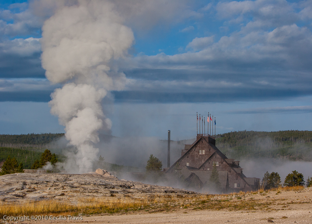
![]() Mammoth Hot Springs. There are accessible boardwalk from which you can view the Mammoth Hot Springs Terraces.
Mammoth Hot Springs. There are accessible boardwalk from which you can view the Mammoth Hot Springs Terraces.
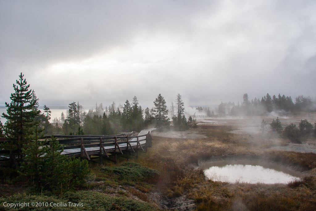
![]() Norris Geyser Basin and Area. There are boardwalks here, but you may need assistance. The lower section of the Artists Paintpots is wheelchair accessible.
Norris Geyser Basin and Area. There are boardwalks here, but you may need assistance. The lower section of the Artists Paintpots is wheelchair accessible.
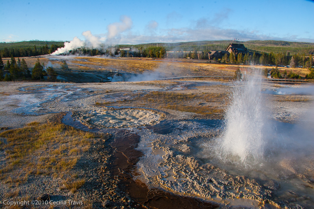
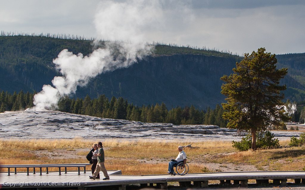
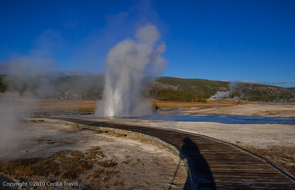
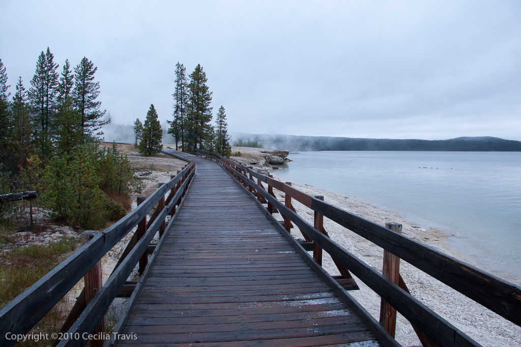
![]() Old Faithful. There are accessible paved trails and boardwalks going to Old Faithful Geyser, Geyser Hill, and Castle Geyser
Old Faithful. There are accessible paved trails and boardwalks going to Old Faithful Geyser, Geyser Hill, and Castle Geyser
![]() West Thumb Geyser Area. You may require some assistance on these boardwalks, which are by Yellowstone Lake.
West Thumb Geyser Area. You may require some assistance on these boardwalks, which are by Yellowstone Lake.
![]() Fishing Bridge Area. There is an accessible trail to the Mud Volcano, 6 miles north of Fishing Bridge.
Fishing Bridge Area. There is an accessible trail to the Mud Volcano, 6 miles north of Fishing Bridge.
![]() Grand Canyon of the Yellowstone River. There are a number of accessible trails to overlooks. See the map in the Accessibility Guide.
Grand Canyon of the Yellowstone River. There are a number of accessible trails to overlooks. See the map in the Accessibility Guide.
Glacier National Park
Glacier National Park
Glacier National Park’s 1,583 square miles contain “…pristine forests, alpine meadows, rugged mountains, and spectacular lakes.” The Park habitats encompass several ecotones and exhibit a wide variety of macro and micro habitats. There are 26 glaciers, all of them shrinking. Glacier shares a 21 mile (33.7 km) border with Canada’s Waterton National Park. Bring your passport and visit them both by driving the Going To The Sun highway.
Here is the Park website. Accessible Facilities and Services.
Phone 406-888-7800
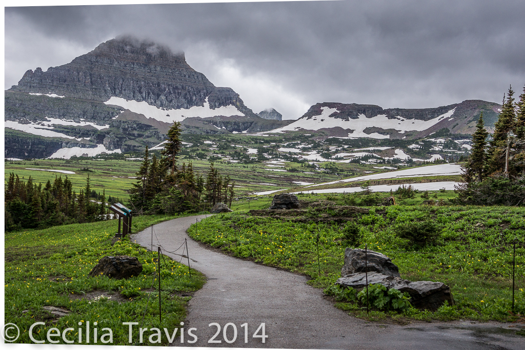
![]() There is an accessible nature trail from the Visitors Center on Logan Pass. Be sure to bring warm, wind and rain-proof clothing.
There is an accessible nature trail from the Visitors Center on Logan Pass. Be sure to bring warm, wind and rain-proof clothing.
![]()
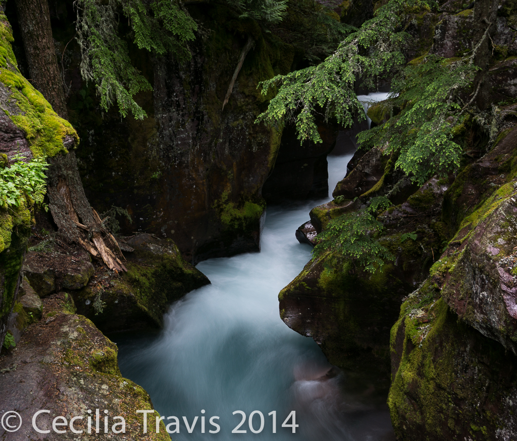
Trail of the Cedars – a short wheelchair accessible loop trail through cedar forest.
As described in EveryTrail.com.
![]() Running Eagle Falls – According to Glacier Guides Montana Raft, this is a “1 mile loop with 15 feet elevation gain.” It is “on your way into the Two Medicine valley.”
Running Eagle Falls – According to Glacier Guides Montana Raft, this is a “1 mile loop with 15 feet elevation gain.” It is “on your way into the Two Medicine valley.”
Idaho Panhandle National Forests
Idaho Panhandle National Forests
The 2.5 million acres of the Idaho Panhandle National Forests contain mountains, lakes, rivers, waterfalls, ancient cedar groves, and an abundance of wildlife. From NationalForests.org: “The Idaho Panhandle National Forests are an aggregation of the Coeur d’Alene and portions of the Kaniksu and St. Joe National Forests. There are eight local points of contact including the Supervisor’s Office, six district offices and the Coeur d’Alene Tree Nursery.” The Forests extend into eastern Washington and western Montana. Supervisor’s Office phone 208-765-7223. See their website for District Rangers’ phones. Publications
![]() Pulaski Tunnel Trail The forest service says that the first 725 feet of trail are accessible to visitors with disabilities.
Pulaski Tunnel Trail The forest service says that the first 725 feet of trail are accessible to visitors with disabilities.
![]() Hobo Cedar Grove Trail From the website: “The trail has a gentle gradient making it accessible to older persons or those with moderate physical impairments. The trail width is about 40 inches. An occasional log bench provides seating along the trail.”
Hobo Cedar Grove Trail From the website: “The trail has a gentle gradient making it accessible to older persons or those with moderate physical impairments. The trail width is about 40 inches. An occasional log bench provides seating along the trail.”
![]() Hiawatha Rail Trail is not listed in the Rails-to-Trails site, but I have seen references to wheelchair use. Call 208-744-1301. Here is some more information from the Friends of the Coeur d’Alene Trails. You can also give the Forest Service a call at (208) 765-7223.
Hiawatha Rail Trail is not listed in the Rails-to-Trails site, but I have seen references to wheelchair use. Call 208-744-1301. Here is some more information from the Friends of the Coeur d’Alene Trails. You can also give the Forest Service a call at (208) 765-7223.
![]() Mineral Point Trail is 2.1 miles one way and described as “….one of the most beautiful trails on the Sandpoint Ranger District and is popular with hikers and mountain bikers. Gentle grades, wildflowers and excellent views make this trail suitable for the entire family.”
Mineral Point Trail is 2.1 miles one way and described as “….one of the most beautiful trails on the Sandpoint Ranger District and is popular with hikers and mountain bikers. Gentle grades, wildflowers and excellent views make this trail suitable for the entire family.”
![]() Sam Owen Trail is “wheelchair moderate, hiker easy……The first ½ mile of this trail has a hardened surface that is suitable for wheel chairs and strollers. The hardened trail ends at a beautiful vista of Owens Bay and the benches offer a nice place to sit and enjoy the view. The remaining ½ mile of trail is native surface, narrow and not suitable for wheel chairs or strollers…..This is a great hike for a family with small children. ”
Sam Owen Trail is “wheelchair moderate, hiker easy……The first ½ mile of this trail has a hardened surface that is suitable for wheel chairs and strollers. The hardened trail ends at a beautiful vista of Owens Bay and the benches offer a nice place to sit and enjoy the view. The remaining ½ mile of trail is native surface, narrow and not suitable for wheel chairs or strollers…..This is a great hike for a family with small children. ”