Santa Fe National Forest
The Santa Fe National Forest holds 1.6 million acres of mountain scenery, the headwaters of Pecos, Jemez, and Gallinas Rivers, mountain streams and lakes. It includes four wilderness areas and 1,000 miles of hiking trails.
Here is the Forest website. Phone 505-438-5300. Thanks to Clifton Russell for suggestions of accessible trails in Santa Fe National Forest.
![]() There is a paved trail with fishing access spots along the San Antonio River at San Antonio Campground. Thank you, Katie Watson, for the reference.
There is a paved trail with fishing access spots along the San Antonio River at San Antonio Campground. Thank you, Katie Watson, for the reference.
![]() San Diego Canyon Overlook site in the Jemez Ranger District.
San Diego Canyon Overlook site in the Jemez Ranger District.
There is a paved trail to the overlook as well as ADA restroom.
![]() East Fork Trail (Forest trail 137) just off NM State Highway 4. Also in Jemez Ranger District. “This [10 mile] trail would be suitable for elderly, but maybe too challenging for wheel chairs.” It sounds as if parts of it would be OK. “From Jemez Falls it’s another mile to the East Fork Trailhead. This segment of trail is an easier walk, although still moving uphill. From the East Fork Trailhead to the Las Conchas Trailhead the hiking becomes easier with rolling terrain.” I suggest you contact Forest Headquarters (505) 438-5300 for advice on the parts appropriate for you.
East Fork Trail (Forest trail 137) just off NM State Highway 4. Also in Jemez Ranger District. “This [10 mile] trail would be suitable for elderly, but maybe too challenging for wheel chairs.” It sounds as if parts of it would be OK. “From Jemez Falls it’s another mile to the East Fork Trailhead. This segment of trail is an easier walk, although still moving uphill. From the East Fork Trailhead to the Las Conchas Trailhead the hiking becomes easier with rolling terrain.” I suggest you contact Forest Headquarters (505) 438-5300 for advice on the parts appropriate for you.
![]() Cowles Fishing Pond in the Pecos/Las Vegas Ranger District. “An ADA accessible trail around both ponds was completed on 5/25/2013.”
Cowles Fishing Pond in the Pecos/Las Vegas Ranger District. “An ADA accessible trail around both ponds was completed on 5/25/2013.”
Here are some accessible picnic and camping areas that Clifton Russell brought to my attention:
Pecos/Las Vegas Ranger District
Windy Bridge
Baker Flat
Lower Dalton
Española Ranger District
Black Canyon Campground
Big Tesuque Campground
Category: New Mexico Federal
Rio Grande del Norte National Monument
Río Grande del Norte National Monument
“The Río Grande del Norte National Monument is comprised of rugged, wide open plains at an average elevation of 7,000 feet, dotted by volcanic cones, and cut by steep canyons with rivers tucked away in their depths. The Río Grande carves an 800 foot deep gorge through layers of volcanic basalt flows and ash.”
Here is their website. Here is a more descriptive website from Taos.org. Phone for office in Taos 575-758-8851 Map
Rio Grande Visitor Center 575-751-4899 Wild Rivers Visitor Center 575-586-1150
The descriptions below are from a website I can no longer find. Call ahead to be sure about the ease of these trails.
Upper Gorge (Wild Rivers)
![]() Wild Rivers Nature Trail “is an easy interpretive loop along the canyon rims of the Red River and the Rio Grande at La Junta Point. The trail is approximately 1/2 mile long.”
Wild Rivers Nature Trail “is an easy interpretive loop along the canyon rims of the Red River and the Rio Grande at La Junta Point. The trail is approximately 1/2 mile long.”
![]() Rinconada Loop Trail is a 6.1 mile loop which you could do parts of from the campgrounds. A wheelchair user would probably need some assistance.
Rinconada Loop Trail is a 6.1 mile loop which you could do parts of from the campgrounds. A wheelchair user would probably need some assistance.
![]() Chawalauna Overlook is about 1/4 mile from the parking lot and according to the very helpful Monument manager, John Bailey, has a lovely rim view.
Chawalauna Overlook is about 1/4 mile from the parking lot and according to the very helpful Monument manager, John Bailey, has a lovely rim view.
![]() Trails leading north and south from the Wild Rivers Visitor Center have gravel in places, making them probably too difficult for wheelchair users.
Trails leading north and south from the Wild Rivers Visitor Center have gravel in places, making them probably too difficult for wheelchair users.
![]() Pescado Trail from the Visitor Center is pretty easy for the first 1/2 mile and takes you to a great view of the river gorge. A wheelchair user might need assistance.
Pescado Trail from the Visitor Center is pretty easy for the first 1/2 mile and takes you to a great view of the river gorge. A wheelchair user might need assistance.
Lower Gorge (Orilla Verde)
![]() The first 1 1/4 mile of the 9 mile West Rim Trail going south from the Rio Grande Gorge Bridge (High Bridge) is easy, flat, and smooth. There is a bench which would make a good turn-around spot for limited walkers.
The first 1 1/4 mile of the 9 mile West Rim Trail going south from the Rio Grande Gorge Bridge (High Bridge) is easy, flat, and smooth. There is a bench which would make a good turn-around spot for limited walkers.
![]() La Vista Verde is 1.3 miles and easy, but does have 6 steps near the beginning.
La Vista Verde is 1.3 miles and easy, but does have 6 steps near the beginning.
Taos Valley Overlook
![]() Trader’s Trail is an easy 1.8 mile with a steady, not too steep slope.
Trader’s Trail is an easy 1.8 mile with a steady, not too steep slope.
Socorro Nature Area
Socorro Nature Area
“The Socorro Nature Area is a 120-acre environmental education area in the Rio Grande Bosque. The area includes a 1/2-mile self-guiding nature walk with interpretive signs, a pond, and amphitheatre.”
Here is the BLM Area website. and here is a more informative website from Soccorronm.org. Phone 575-835-0412 Interpretive Trail Guide
![]() The first .11 mile of this self-guiding nature walk goes to the pond and is wheelchair accessible. On the guide, there are two loop trails which add up to about a mile and are very easy. According to the manager, you could possibly do them in a wheelchair, if you had help getting through some soft patches. Call 575-835-0412 for information.
The first .11 mile of this self-guiding nature walk goes to the pond and is wheelchair accessible. On the guide, there are two loop trails which add up to about a mile and are very easy. According to the manager, you could possibly do them in a wheelchair, if you had help getting through some soft patches. Call 575-835-0412 for information.
Perea Nature Trail
Perea Nature Trail
“A mountain peak dominates the one-mile Perea Nature Trail — located just outside the village of San Ysidro in northwest New Mexico. The mountain highlights the Jemez Mountain Range, which is the southern start of the Rocky Mountains that extend northward to Alaska.”
Here is a website for the Trail. Phone 505-761-8700
![]() This one mile (or 0.8 or 0.9 depending on the source of information) loop trail “features beautiful wild flowers and is good for all skill levels.” Here is AllTrails description.
This one mile (or 0.8 or 0.9 depending on the source of information) loop trail “features beautiful wild flowers and is good for all skill levels.” Here is AllTrails description.
Kasha-Katuwe Tent Rocks National Monument
Kasha-Katuwe Tent Rocks National Monument
Here is the Monument website. Phone 505-331-6259 Be sure to call ahead to be sure of trail conditions. Here is a nice description from newmexiconomad.
![]() “The Cave Loop Trail is 1.2 miles long, rated as easy and portions are ADA accessible” It is not clear as to what portions so do call ahead. Reviews on Trip Advisor.
“The Cave Loop Trail is 1.2 miles long, rated as easy and portions are ADA accessible” It is not clear as to what portions so do call ahead. Reviews on Trip Advisor.
![]() “The Veterans Memorial Trail is a 1-mile long loop trail, rated as very easy and is wheel chair accessible. The Veterans Memorial is located at the end of a 3 mile long gravel surfaced road overlooking picturesque Peralta Canyon and Jemez Mountain peaks. “
“The Veterans Memorial Trail is a 1-mile long loop trail, rated as very easy and is wheel chair accessible. The Veterans Memorial is located at the end of a 3 mile long gravel surfaced road overlooking picturesque Peralta Canyon and Jemez Mountain peaks. “
El Malpais National Conservation Area
El Malpais National Conservation Area
“The richly diverse volcanic landscape of El Malpais offers solitude, recreation, and discovery. Explore cinder cones, lava tube caves, sandstone bluffs, and hiking trails. Wildlife abounds in the open grasslands and forests. ”
Here is the Area website from the BLM. Here is another from the National Park Service. Map Call the BLM at 505-287-7911 or the Northwest New Mexico Visitor Center 505-876-2783 for information about the trails. I am not sure how easy the footing is on them.
![]() ? The 1/2 mile round trip hike to La Ventana Natural Arch is described as “relatively easy”.
? The 1/2 mile round trip hike to La Ventana Natural Arch is described as “relatively easy”.
![]() ? The Ranger Station Nature Trail is a 1 1/4 mile loop with an elevation gain of 125 feet.
? The Ranger Station Nature Trail is a 1 1/4 mile loop with an elevation gain of 125 feet.
Valley of Fires Recreation Area
Valley of Fires Recreation Area
“Valley of Fires Recreation Area is beside the Malpais Lava Flow. About 5,000 years ago, Little Black Peak erupted and flowed 44 miles into the Tularosa Basin, filling the basin with molten rock. The resulting lava flow is four to six miles wide, 160 feet thick and covers 125 square miles. The lava flow is considered to be one of the youngest lava flows in the continental United States.” Despite its barren appearance from distance, you will find a wealth of plants and wildlife.
Here is the Area website. Phone 575-648-2241 or 575-840-6243
Described in Americansouthwest.net
![]() Malpais Nature Trail “….when you walk through the nature trail there are many varieties of flowers, cactus, trees and bushes typical of the Chihuahuan desert. There is a juniper that is said to be 400 years old. The lava is similar to Hawaiian lava, jagged and rippled, and most of the lava field is a wilderness study area. The self-guided …. Trail is paved for 1 /3 mile, fully accessible for individuals with disabilities. Interpretive brochures are available at the trailhead near the group shelter. In addition to the flora, fauna abound. There are bats, roadrunners, quail, cottontails,lizards, great horned owls, burrowing owls, buzzards, hawks, gnat catchers, cactus wrens, sparrows and golden eagles, a virtual birdwatcher’s paradise.”
Malpais Nature Trail “….when you walk through the nature trail there are many varieties of flowers, cactus, trees and bushes typical of the Chihuahuan desert. There is a juniper that is said to be 400 years old. The lava is similar to Hawaiian lava, jagged and rippled, and most of the lava field is a wilderness study area. The self-guided …. Trail is paved for 1 /3 mile, fully accessible for individuals with disabilities. Interpretive brochures are available at the trailhead near the group shelter. In addition to the flora, fauna abound. There are bats, roadrunners, quail, cottontails,lizards, great horned owls, burrowing owls, buzzards, hawks, gnat catchers, cactus wrens, sparrows and golden eagles, a virtual birdwatcher’s paradise.”
Bosque Del Apache National Wildlife Refuge
Bosque Del Apache National Wildlife Refuge
Bosque Del Apache National Wildlife Refuge is one of the most popular bird photography places in the American West. It lies between the Chupadera Mountains to the west and the San Pascual Mountains to the east and is a critical stopover for migrating waterfowl. The refuge is well known for the tens of thousands of cranes, geese, and ducks that winter here each year.
Here is the Refuge website. Trail descriptions The website does not state the difficulty of these trails. Most sound pretty easy, but you should call ahead or check with the visitor center. Phone 575-835-1828. There are more trails than I have listed below.
![]() Marsh Overlook Trail is an easy 1.5 mile walk around a seasonally flooded wetland.
Marsh Overlook Trail is an easy 1.5 mile walk around a seasonally flooded wetland.
![]() Boardwalk Trail 0.5 mile round trip
Boardwalk Trail 0.5 mile round trip
![]() Rio Viejo Trail is 1.7 mile round trip along a former channel of the Rio Grande.
Rio Viejo Trail is 1.7 mile round trip along a former channel of the Rio Grande.
![]() Desert Arboretum 0.25mi. described as “mostly accessible”.
Desert Arboretum 0.25mi. described as “mostly accessible”.
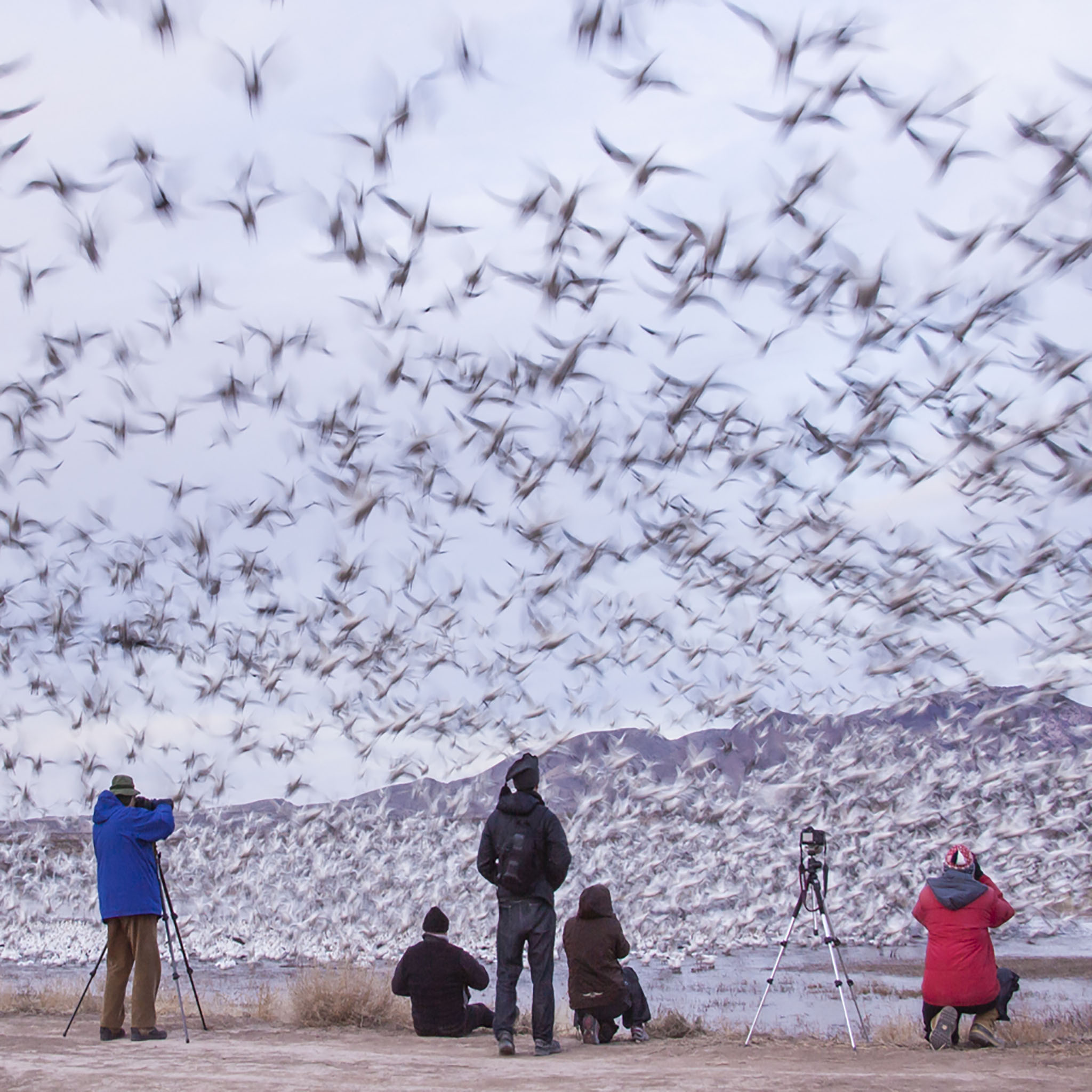
You can see thousands of waterbirds and photograph them from your car. Thank you Cathy & Gordon Illg for this shot of snow geese and photographers.