Siuslaw National Forest
“…the Siuslaw National Forest stretches from the lush forests of the coastal mountains to the unique Oregon Dunes and the beaches of the Pacific Ocean.”
Here is the Forest website. phone 541-750-7000 Accessible trails and viewing platforms
![]() Oregon Dunes Loop Trail #1334 The first 1/2 mile of this trail is paved and goes to a viewing area and several picnic sites.
Oregon Dunes Loop Trail #1334 The first 1/2 mile of this trail is paved and goes to a viewing area and several picnic sites.
![]() Sutton Trails #1321 Map This includes the Holman Vista Trail #1326 (accessible to the viewing deck) and Darlingtonia Trail #1320, a boardwalk across a bog with carnivorous plants.
Sutton Trails #1321 Map This includes the Holman Vista Trail #1326 (accessible to the viewing deck) and Darlingtonia Trail #1320, a boardwalk across a bog with carnivorous plants.
Category: Oregon Federal
Accessible Adventure Videos by NFS
Accessible Adventures in the Pacific Northwest Videos The US Forest Service has produced a series of videos (33 as of August 2016) narrated by John Williams. These five to six minute videos visit National Forests and Scenic Byways in Washington and Oregon, letting you see just how accessible (or not) many of these wonderful places are.
Willamette National Forest
Willamette National Forest
The 1.6 million acres Willamette National Forest is offers a…” varied landscape of high mountains, narrow canyons, cascading streams, and wooded slopes”.
Here is the Forest website. Supervisor phone 541-225-6300 Links to maps.
Try calling the Ranger District offices for easy trail ideas: Detroit Ranger District 503-854-3366, Sweet Home Ranger District 541-367-5168, McKenzie River Ranger District 541-822-3381, Middle Fork Ranger District 541-782-2283.
![]() Walton Ranch Interpretive Trail #4170 1/4 mile fine gravel surface with an elevation gain of 100′. “The trail crosses Trout Creek and ends at two viewing platforms. The first platform provides a view of the Walton Ranch site and wildlife habitat area. The second platform provides a better view of the west end of the meadow, where elk concentrate during winter months.”
Walton Ranch Interpretive Trail #4170 1/4 mile fine gravel surface with an elevation gain of 100′. “The trail crosses Trout Creek and ends at two viewing platforms. The first platform provides a view of the Walton Ranch site and wildlife habitat area. The second platform provides a better view of the west end of the meadow, where elk concentrate during winter months.”
![]() Accessible Adventures: McKenzie Pass National Scenic Byway on the Willamette National Forest is a video on YouTube. Several accessible trails and overlooks are illustrated in the video.
Accessible Adventures: McKenzie Pass National Scenic Byway on the Willamette National Forest is a video on YouTube. Several accessible trails and overlooks are illustrated in the video.
Mt. Hood National Forest
Mt. Hood National Forest
“Mt. Hood National Forest extends south from the strikingly beautiful Columbia River Gorge across more than sixty miles of forested mountains, lakes and streams…”
Here is the Forest website. phone 503-668-1700 Links to maps
![]() Lost Lake Loop at Lost Lake Campground 3.2 mile, described as “nearly level”. There are accessible fishing piers along the eastern lake shore, with some accessible paths. Described by OregonHikers.org
Lost Lake Loop at Lost Lake Campground 3.2 mile, described as “nearly level”. There are accessible fishing piers along the eastern lake shore, with some accessible paths. Described by OregonHikers.org
Columbia River Gorge National Scenic Area
Columbia River Gorge National Scenic Area
“The Columbia River Gorge National Scenic Area protects the spectacular canyon where the Columbia River cuts through the Cascade mountains – with cliffs and overlooks of Washington to the north and Oregon’s mountains and waterfalls to the south.”
Here is the Area website.
Map Video of Accessible Adventures phone (541) 308-1700
![]() Catherine Creek Trail #4400 is a one mile paved trail “with great views of the Columbia River on the south side of the county road. …….. Some individuals with disabilities may need assistance on the Catherine Creek Trail.” Here is a description from OregonHikers.org. This is part of the Burdoin/Coyote Wall/Catherine Creek Recreation Area Day hiking trails
Catherine Creek Trail #4400 is a one mile paved trail “with great views of the Columbia River on the south side of the county road. …….. Some individuals with disabilities may need assistance on the Catherine Creek Trail.” Here is a description from OregonHikers.org. This is part of the Burdoin/Coyote Wall/Catherine Creek Recreation Area Day hiking trails
![]() St. Cloud Trail #4410 is a “Short loop through an old apple orchard. Interpretive signs explain the historical importance of the area.”
St. Cloud Trail #4410 is a “Short loop through an old apple orchard. Interpretive signs explain the historical importance of the area.”
![]() Sandy River Delta Trail #4417 is a 1.1 mile compact gravel trail to the Sandy River Confluence bird blind site. Map
Sandy River Delta Trail #4417 is a 1.1 mile compact gravel trail to the Sandy River Confluence bird blind site. Map
![]() Balfour-Klickitat Trail #4414 0.7 miles. “….offers unique views of the Columbia and the Klickitat rivers as well as wildflower and birdwatching opportunities.” The trail is “paved and accessible with a 0-15% gradient. Most of the trail is ADA accessible; some people with disabilities may need assistance.” Described by OregonHikers.org.
Balfour-Klickitat Trail #4414 0.7 miles. “….offers unique views of the Columbia and the Klickitat rivers as well as wildflower and birdwatching opportunities.” The trail is “paved and accessible with a 0-15% gradient. Most of the trail is ADA accessible; some people with disabilities may need assistance.” Described by OregonHikers.org.
![]() Sams Walker Trail #4402 a 1.1 mile loop. “…good views of the Oregon side of the Gorge and picnic tables at the viewpoint. It is 3 feet wide and surfaced with crushed gravel.” Described by OregonHikers.org
Sams Walker Trail #4402 a 1.1 mile loop. “…good views of the Oregon side of the Gorge and picnic tables at the viewpoint. It is 3 feet wide and surfaced with crushed gravel.” Described by OregonHikers.org
Hell’s Canyon Overlook
Hell’s Canyon Overlook –
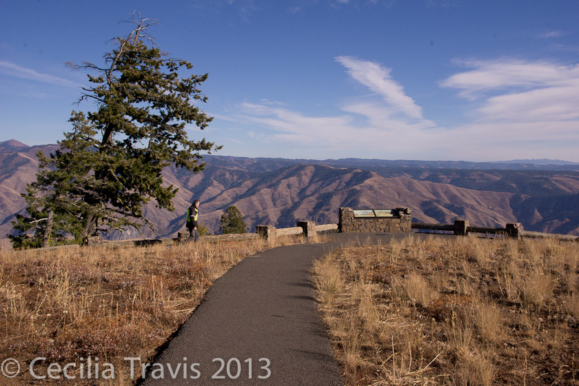
“Situated off the Hells Canyon Scenic Byway, the Hells Canyon Overlook provides a dramatic panorama of Hells Canyon and the Seven Devils Mountains. The area hosts outstanding wildflower viewing both en route along the scenic byway and at the overlook.” Phone 541-426-4978 Here is their website.
![]() From the wheelchair accessible overlook you look east across the Snake River towards Idaho. There are accessible toilets.
From the wheelchair accessible overlook you look east across the Snake River towards Idaho. There are accessible toilets.
Crater Lake National Park
Crater Lake National Park –
“Most of the park’s 183,000 acres are in the backcountry, and are generally inaccessible to visitors with mobility impairments. However, several front-country trails are fully accessible, and others have portions that may be negotiable with assistance.”
Here is the Park website. Accessibility Maps Phone 541-594-3000
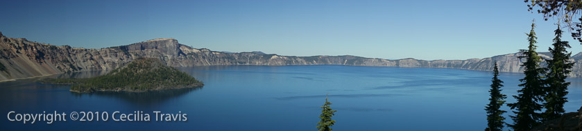
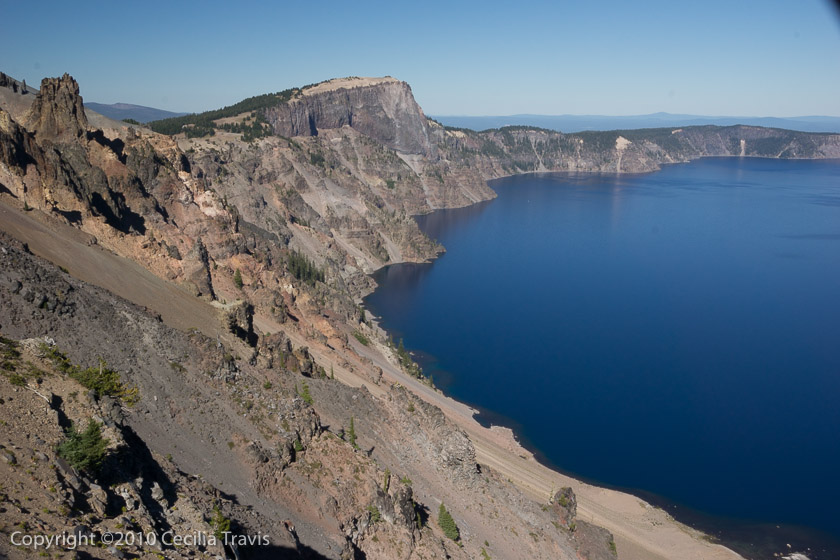
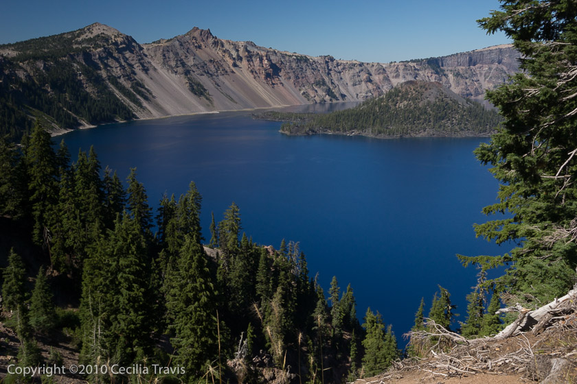
![]() There is an accessible concrete walkway at the main viewing area for Crater Lake. Another viewing area, the Watchman Overlook, has a ramp to its deck. We didn’t get to them, but there are three short trails in the forest described as “Accessible to wheelchair users with assistance”. These are The Pinnacles, Godfrey Glen, and the first 3/4 of the 2.2 mile Plaikni Falls trail.
There is an accessible concrete walkway at the main viewing area for Crater Lake. Another viewing area, the Watchman Overlook, has a ramp to its deck. We didn’t get to them, but there are three short trails in the forest described as “Accessible to wheelchair users with assistance”. These are The Pinnacles, Godfrey Glen, and the first 3/4 of the 2.2 mile Plaikni Falls trail.