John Heinz National Wildlife Refuge at Tinicum
“The refuge protects a variety of habitats for birds in the highly urbanized landscape of greater Philadelphia.”
Here is their website. Phone 215-365-3118 Brochure and Map
![]() Darby Creek. Thank you to Park Ranger Suzanne Kelley who writes that “We have a .6 mile accessible loop – the asphalt path, about 8′ wide, goes between Darby Creek and the impoundment (big man-made pond), crosses the impoundment on a boardwalk and comes back to the visitor center or parking lot through the woods on an asphalt path about 6′ wide. Just past the boardwalk is our accessible fishing deck – the asphalt goes up to it. The visitor center is also accessible…The rest of the service roads and paths are hard packed dirt, gravel. and wood chip. The terrain in general is flat with minor hills towards the center of the refuge.”
Darby Creek. Thank you to Park Ranger Suzanne Kelley who writes that “We have a .6 mile accessible loop – the asphalt path, about 8′ wide, goes between Darby Creek and the impoundment (big man-made pond), crosses the impoundment on a boardwalk and comes back to the visitor center or parking lot through the woods on an asphalt path about 6′ wide. Just past the boardwalk is our accessible fishing deck – the asphalt goes up to it. The visitor center is also accessible…The rest of the service roads and paths are hard packed dirt, gravel. and wood chip. The terrain in general is flat with minor hills towards the center of the refuge.”
Category: Pennsylvania Federal
Allegheny National Forest
Allegheny National Forest
” Situated in the foothills of the Appalachian mountains, the ANF is composed of plateau tops with elevations up to approximately 2,300 feet and valleys down to approximately 1,000 feet above sea level. The forest is approximately 517,000 acres and includes land in Elk, Forest, McKean and Warren counties in the northwestern corner of the state. ”
Here is the Forest website. Phone 814-728-6100 Allegheny National Forest Visitors Bureau phone 800-473-9370 Regional Map Maps and Brochures. List of trails with links to descriptions. There are several trails described as “easy”, but you will need to call ahead to learn more. Try the Bradford Ranger District 814-363-6000 or the Marienville Ranger District 814-927-5700
![]() Shawmut Trail is 2 miles that “partially follows Marvin Creek and traverses wooded settings, open meadows and farm land.”
Shawmut Trail is 2 miles that “partially follows Marvin Creek and traverses wooded settings, open meadows and farm land.”
![]() Timberdoodle Flats Interpretive Trail is “Two trail loops totaling 1.4 miles. The Woodcock Loop is marked with a yellow woodcock insignia and features 12 interpretive stops. The shorter Bluebird trail is suitable for wheelchairs or walking assistance equipment and features six interpretive stops.” Description from Forest Service
Timberdoodle Flats Interpretive Trail is “Two trail loops totaling 1.4 miles. The Woodcock Loop is marked with a yellow woodcock insignia and features 12 interpretive stops. The shorter Bluebird trail is suitable for wheelchairs or walking assistance equipment and features six interpretive stops.” Description from Forest Service
Erie National Wildlife Refuge
Erie National Wildlife Refuge
Here is the Refuge website. Phone: 814-789-3585 Brochure There are five nature trails here. Some of them sound pretty easy. Call to see if they would be easy for you.
![]() Muddy Creek Holly Trail Map “This out-and-back trail stretches a mile over the glacial and riverine sediments of Muddy Creek’s valley. The terrain is flat to gently rolling with an environment of meadows, marshes, oxbow sloughs, and intermediate and mature forests….A four foot wide boardwalk provides excellent access for the handicapped and others in this seasonally wet area.”
Muddy Creek Holly Trail Map “This out-and-back trail stretches a mile over the glacial and riverine sediments of Muddy Creek’s valley. The terrain is flat to gently rolling with an environment of meadows, marshes, oxbow sloughs, and intermediate and mature forests….A four foot wide boardwalk provides excellent access for the handicapped and others in this seasonally wet area.”
![]() ? Beaver Run Trail is a 1 mile loop
? Beaver Run Trail is a 1 mile loop
Delaware Water Gap National Recreation Area

Delaware Water Gap National Recreation Area The Delaware Water Gap national Recreation area is 67,00 acres of mountains and valleys, including 40 miles of the Middle Delaware River and 27 miles of the Appalachian Trail. There are waterfalls, rhododendron ravines, and hemlock forests.
Here is the Area website. Phone 570-426-2452
Map Accessibility
![]()
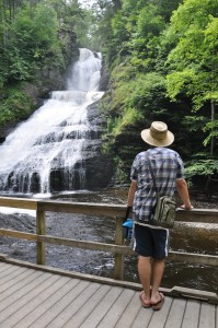
Dingmans Creek Trail A lovely 0.4 mile one way boardwalk trail takes you past the 80′ Silverthread Falls to Dingmans Falls which drop 130′. The trail is stroller and wheelchair accessible.
![]() McDade Recreational Trail Parts of this trail are accessible, such as Smithfield Beach to Riverview and Bushkill Village to Jerry Lees. However, you should call the park, 570-426-2452 to be sure these sections are appropriate for you.
McDade Recreational Trail Parts of this trail are accessible, such as Smithfield Beach to Riverview and Bushkill Village to Jerry Lees. However, you should call the park, 570-426-2452 to be sure these sections are appropriate for you.
![]()
![]() Pocono Environmental Education Center has a 1/4 mile rope-lined sensory trail.
Pocono Environmental Education Center has a 1/4 mile rope-lined sensory trail.