Manassas National Battlefield Park

Manassas National Battlefield Park
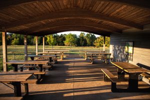
Mantissas National Battlefield Park’s 4,400 acres acres are “characterized by gently rolling hills with a patchwork of open fields and forests.”  Audubon Society  has named it a Northern Virginia Birding Hotspot. “The park has developed a series of loop trails that traverse key areas of the First and Second Manassas Battlefields. ”    Thank you to Bryan Gorsira with the Park Service who wrote to tell me of new accessible trails at Manassas. From Bryan: “The Brownsville picnic area is located in the south western portion of the park and has a large parking lot, accessible restroom facilities, and a covered pavilion with accessible picnic tables, and a ¼ mile wheelchair accessible natural resource education trail. ”
Here is the Park website.   Phone 703-361-1339   Accessibility     Trail Map
For a detailed description of the trails see National Park Planner.
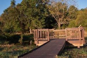
Wheelchair AccessibleBrownsville Picnic Area Loop 0.25 mile  “This trail is a gently rolling hard surface loop trail that leaves from the pavilion and restrooms, though fields and near a stream, past a small pond with a wheelchair accessible dock, and back to the pavilion.”
Wheelchair AccessibleThe Stone Bridge Trail is about 400′ and goes to an overlook with wayside markers at the bridge.
Wheelchair AccessibleChinn Ridge Trail  0.5 mile ADA paved extends along the crest of Chinn Ridge with several interpretive markers focusing on the Second Battle of Manassas.
Wheelchair AccessibleBrawner Farm Trail about 800′ and provides access to the Brawner Farm.
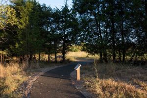
Wheelchair Accessible Brownsville Picnic Area Loop, Manassas Battlefield National Park
Accessible Brownsville Picnic Area Loop, ©Manassas Battlefield Nat’l Park
Accessible Fishing Dock©Manassas Battlefield National Park
Accessible Fishing Dock ©Manassas Battlefield National Park
Accessible Pavilion @Manassas Battlefield National Park

George Washington and Jefferson National Forests

George Washington and Jefferson National Forests
 “The Jefferson National Forest is comprised of lands located in Virginia, West Virginia and Kentucky. The George Washington National Forest is comprised of lands located in Virginia and West Virginia.”  Both of these Forests are primarily in Virginia.   I am putting this one post in the pages for all three states.  There are a ton of trails, many of them described as easy.  You might pick an area you want to visit and call the appropriate Ranger District for advice.   Here are phone numbers for the eight Ranger Districts.  Supervisor’s Office Phone 540-265-5100.    Links to Maps  Day Hikes  National Forests Foundation     Here is the Forests’ website.

Wheelchair Accessible Massanutten Storybook Trail in Lee Ranger District  0.5 miles described in  Virginia Trail Guide.  “…leads to a spectacular view overlooking the Blue Ridge Mountains and Shenandoah Valley. Learn from the interpretive signs of how the Massanutten Mountains were formed.”
Wheelchair AccessibleLions Tale Accessible Trail for the Visually Impaired in Lee Ranger District  0.5 mile interpretive loop. Waymarking.com  Backpacker.com “Listen to the gentle ripples of Passage Creek, feel the refreshing water running from the flume, and smell the sweet aromas of sassafras and birch.”
Wheelchair AccessiblePandapas Pond Loop Trail Eastern Divide Ranger District 0.9 mile  “The pond is situated in a hardwood forest. Rhododendron and flame azalea are abundant. … The trail encircles both the pond and the adjacent wetland.”
Wheelchair AccessibleFenwick Nature Walk Trail Eastern Divide Ranger District. 1.0 mile.  “…hikers can walk through an Appalachian forest, cross Mill Creek, pass through swampy wetlands, and get a nice view of a scenic waterfall. Wildflowers are abundant during the spring.”
Virginias Walk Trail Eastern Divide Ranger District  1.30 miles.  “This 1.3 mile nature trail meanders around White Rocks Campground.”
Wheelchair AccessibleRhododendron Trail  James River Ranger District.  0.12 miles  There is a “…wonderful view of the Rich Hole Wilderness at the end.”
Beartree Lake Trail Mount Rogers National Recreation Area  0.8 miles paved and gravel-surfaced trail which encircles Beartree Lake.
Jackson River Fishing Trail  Warm Springs Ranger District  0.85 miles. Primarily used for fishing access to the Jackson River, the trail follows an old roadbed and has scenic views of the river.
Wheelchair Accessible Hidden Valley West Trail  in Warm Springs Ranger District 1.08 miles.  Follows the Jackson River downstream.

Back Bay National Wildlife Refuge

Back Bay National Wildlife Refuge
“Back Bay NWR includes a thin strip of barrier island coastline typical of the Atlantic and Gulf coasts, as well as upland areas on the west bank of Back Bay. Habitats include beach, dunes, woodlands, agricultural fields, and emergent freshwater marshes. ”  The Refuge is just southeast of Virginia Beach.
Here is the Refuge website.    Map     Overview Map
Winter Trails Map  Summer Trails Map       phone 757-301-7329 x3106
Trails  The seven trails listed here range in length from 0.1 to 3.15 miles and all are described as having a gentle grade (0 to 5%), with varied cross slopes.

Mason Neck National Wildlife Refuge

Mason Neck National Wildlife Refuge
Elizabeth Hartwell Mason Neck National Wildlife Refuge …. “provides wildlife a relatively remote area of upland forests and freshwater marshes extending into the Potomac River. The Refuge habitats host over 211 bird species, more than 200 plant species, 31 mammal species, and 40 species of reptiles and amphibians.”
Here is the Refuge website.   Phone  703/490-4979   Map  Brochure
Wheelchair AccessibleJoseph V. Gartlan Great Marsh Trail 0.75 mile paved trail “…following a forested peninsula and ending at an observation platform overlooking the Great Marsh.”
Wheelchair Accessible  High Point Trail 3 mile This ADA compliant paved trail parallels High Point Road and connects the refuge with Mason Neck State Park managed trails and facilities.
?  The 3 mile Woodland Loop Trail looks as though it might be easy, but does cross some streams.  Call to learn more.

Blue Ridge Parkway

Blue Ridge Parkway  
The Parkway is a 469 mile drive “revealing stunning long-range vistas and close-up views of the rugged mountains and pastoral landscapes of the Appalachian Highlands.” The Blue Ridge Parkway is in both Virginia and North Carolina.
Here is their website. Phone 828-348-3400   Recorded Park Information line 828-298-0398
Parkway Visitor Center in Asheville, North Carolina  828-298-5330    Map   Real time open/close road status map   –  Accessibility

The Blue Ridge Parkway in Virginia 
Peaks of Otter
Wheelchair Accessible
Abbot Lake Trail  One mile loop around the lake “…through a woodland forest and open field.
Trails in North Carolina  This site gives mileage and a rating of easy, moderate or strenuous and links to trail maps.  I can not tell just how easy is “easy” and there is no indication whether there might be obstacles such as stairs.
Rocky Knob
Hikerwithcane? Rocky Knob Picnic area trail “… is an easy 1-mile loop and offers a pleasant walk through a mature forest of large oaks, ashes, hickories, Fraser magnolias, hemlocks, and other native trees and shrubs.”

ASSATEAGUE ISLAND NATIONAL SEASHORE

Assateague Island National Seashore
Assateague Island is a 37 mile long island along the coasts of Maryland and Virginia.  Assateague Island Nat’l Seashore “… contains over 37 miles of pristine beach. More than 300 wild ponies wander the beaches, inland pine forest, and salt marshes.”   “The Chincoteague National Wildlife Refuge is located on Assateague Island and is one of the most popular birding destinations in the United States. ”   There are three visitor centers: Chincoteague NWR 757-336-6122,  Tom’s Cove 757-336-6577, and Barrier Island 410-641-1441.   Call the Assateague Island National Seashore Main Line: 410-641-1441 and dial #1 Maryland District Visitor Information to learn more.  Here is the Park Service website.    Here is another website for Assateague Is. Plan Your Visit Brochure
Page on AccessibilityMaryland Trail Map   Virginia Trail Map

Wheelchair AccessibleThere are rental beach wheelchairs.

Wheelchair Accessible

Wheelchair accessible trails in the Maryland District include the Life of the Marsh Trail, the Life of the Forest Trail, and the Bicycle Bridge, all of them 1/2 mile long.
Wheelchair AccessibleWheelchair accessible trails in the Virginia District include Black Dutch Marsh Trail 1 mile, Toms Cove Visitor Center Boardwalk 1/8 mile, Wildlife Loop 3.2 miles, and Woodland Trail 1.6 mile.