Uinta-Wasatch-Cache National Forest “The Uinta-Wasatch-Cache National Forest is one of the 12 National Forests in the Intermountain Region as well as one of the urban National Forests in the Forest Service System. It covers an area that includes northern and north-central Utah, and southwestern Wyoming.” Here is the Forest website. Supervisor phone 801-999-2103 Contacts in the various ranger districts.
There is a video on the website describing 5 Family Friendly Trails which they say are good for strollers and people of all ages. At one point the voice-over claims they are “universally accessible”, but that is not clear from the photographs or the descriptions on the website. ? Limber Pine Nature Trail 1.4 miles
Bridger-Teton National Forest “Located in Western Wyoming, the Bridger-Teton offers more than 3.4 million acres of public land for your outdoor recreation enjoyment. With its pristine watersheds, abundant wildlife and immense wildlands, the Bridger-Teton National Forest comprises a large part of the Greater Yellowstone Ecosystem…” Here is the Forest Website. Phone 307-739-5500
The following trails are described as easy, but some may be more for bikers than hikers. Try calling the trail supervisor at 307-739-5414 for current conditions and an idea of just how easy or not these trails really are. ?Hagen Highway Trail 1.5 miles
?Snow King Nature Trail 0.56 mile loop “This trail is a short loop on top of Snow King Mountain that loops out the ridge and back. It offers great views in all directions as well as lots of flowers. ”
Gros Ventre Wilderness ? Gros Ventre Geological Trail a .43 interpretive loop
Big Horn National Forest “No region in Wyoming is provided with a more diverse landscape – from grasslands to alpine meadows, clear lakes to glacially-carved valleys and rolling hills to sheer mountain cliffs. “ Here is the Forest website. Phone 307-674-2600 Webpage with links to downloadable maps Little Goose Canyon The first 1.75 miles of this 2.8 miles hike trail is not very steep and is rated easy by the Hiking Project. ? Sawmill Lakes Trail #022 0.8 mile This is described as an “Easy trail for day hiking. Accesses Sawmill Lakes. Gently climbs in elevation. Suitable for family outings.” You would be wise to call the Tongue Ranger District at 307-674-2600 for better information. FS Trail #024 1.7 mile
Medicine Bow-Routt National Forests From mountain ranges to grasslands and crystal clear streams, the national forests and national grassland provide abundant and unique opportunities for visitors.
Here is the Forests website. Phones: Forest supervisor 307-745-2300
From stateparks.com: “The Medicine Bow-Routt National Forests extend from north central Colorado to central Wyoming. The Forests encompass portions of many mountain ranges including the Gore Range, Flat Tops, Parks Range, Medicine Bow Mountains, Sierra Madre, and Laramie Range.”
Unfortunately, this branch of the Forest Service gives very little information on trails. Here is the page with links to information each trail, but they seldom give length, let alone difficulty rating. Brush Creek/Hayden Ranger District 307-326-5258 Snowy Range Scenic Byway also described here Mirror Lake Picnic Ground includes an accessible path to the water, campsites and fishing platform. Lake Marie Trail goes along the southeast shore of the Lake
Brooklyn Lake Road 3.5 miles described as easy in Hiking Project.
Arapaho National Wildlife Refuge Complex in northern Colorado and southern Wyoming has an accessible trail and some ADA compliant overlooks. The Hutton Lake National Wildlife Refuge has an easy hiking trail. These refuges are part of a refuge complex that includes one refuge in Colorado and four in southern Wyoming. The headquarters are in Walden, Colorado. Phone 970-723-8528. Here is their website.
Arapaho National Wildlife Refuge is south of Walden, Colorado in North Park, an intermountain glacial basin with an elevation ranging from 8,100 to 8,700′.
Phone 970-723-8202 Moose-Goose Nature Trail 0.5 mile “…winds along the Illinois River, provides a great chance to view song birds and other riparian residents.”
There are three ADA compliant overlooks and an accessible viewing blind.
Hutton Lake National Wildlife Refuge 2.6 miles of hiking trail. “It is possible to hike all or portions of the system. The flat to gently sloping terrain makes it enjoyable for all hikers.” Here is the website for Hutton Lake.
Ashley National Forest
” The Ashley National Forest, with headquarters in Vernal, Utah, comprises 1.3 million acres located in the northeastern portion of Utah and southwestern portion of Wyoming. National Forest System lands are located in three major areas: the northern and southern slopes of the Uinta Mountains, the Wyoming Basin, and the Tavaputs Plateau.” The Forest is mostly in northeastern Utah, with just a bit including the Flaming Gorge in Wyoming.
Here is the Forest website. Phone 435-789-1181 Visitor Guide Yellowpine Interpretive trail 0.5 miles The trail is at the Yellowpine Campground.
Flaming Gorge National Recreation Area “The Flaming Gorge NRA is located in the northeast corner of Utah and the southwest corner of Wyoming.” Ryan, from flaminggorgecountry.com writes that “There are wheel chair accessible nature trails located at Moose Pond, West Green’s Lake, and Red Canyon overlook/Red Canyon Visitor center. Sheep Creek Geological loop, Sheep Creek Bay overlook, Red Canyon overlook, Dowd mountain overlook, Flaming Gorge Dam Visitor Center, and the Dam Vista Overlook are all easy access by vehicle with easy access viewpoints.” Red Canyon Visitor Center 435-889-3713
? The Chamber of Commerce Guide lists six “easy” trails on page 29. Be sure to call either the Visitor Center or the Chamber of Commerce since no details are given. From the website: “Try the short interpretive Nature Trails at Sheep Creek, Moose Ponds, West Greens Lake and Aspen for an easy enlightening walk through a variety of habitats along this scenic drive.” Easy for them might not be easy for you. Check with them.
Grand Teton National Park “Rising above a scene rich with extraordinary wildlife, pristine lakes, and alpine terrain, the Teton Range stands monument to the people who fought to protect it. These are mountains of the imagination. Mountains that led to the creation of Grand Teton National Park where you can explore over two hundred miles of trails, float the Snake River or enjoy the serenity of this remarkable place.” Here is the Park website. Phone 307-739-3300 AccessibilityPark mapMap and Brochure of Lake Shore Hikes Leigh Lake described as one of Ten Easy Hikes from TetonHikingTrails.com by Bill Schneider. 3.7 miles with only 50′ elevation gain. Call the Park first to find about possible obstacles such as rocks and roots. ? Hidden Falls 1.3 mile round trip from Cascade Canyon Trailhead, which you reach by taking a 12″ shuttle boat. This trail is rated “easy” by some sites, but call the Park first to learn if it would be suitable for you. Colter Bay Marina to amphitheater 0.3 mile one way along the east shore of Jackson Lake. Jackson Lake Dam 0.2 mile to good views
Laurance S. Rockefeller Preserve (LSRP) Lake Creek Overlook & Waterfall 0.2 mile packed gravel surface
Multi-use path way Jackson to South Jenny 20 miles, paved
Yellowstone National Park
Yellowstone National Park overlies the huge Yellowstone Caldera. The Park’s diversity and natural wealth include hydrothermal features such as colorful hot springs, mudpots, and geysers. There is abundant wildlife, vegetation, lakes, and the Yellowstone River with its canyon and falls. “In Yellowstone, the interplay between volcanic, hydrothermal, and glacial processes, and the distribution of flora and fauna are intricate.”
The park is in both Wyoming and Montana, so I am posting in both states.
Here is the Park website. Phone 307-344-7381 Accessibility Guide
The Accessibility Guide is very thorough so I am posting just a bit about some of the accessible places in Yellowstone.
“Manual wheelchairs can be rented at medical clinics for $10 per day with a credit card (or $300 cash) deposit. Wheelchairs are available for loan at each lodging facility, except Roosevelt Lodge, and the Old Faithful, Canyon, and Albright (Mammoth) visitors centers while in those areas.”
The use of Segways is somewhat limited. Check ahead.
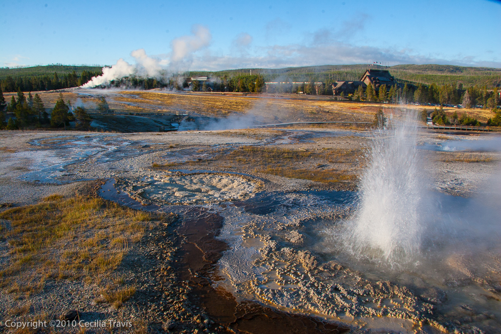
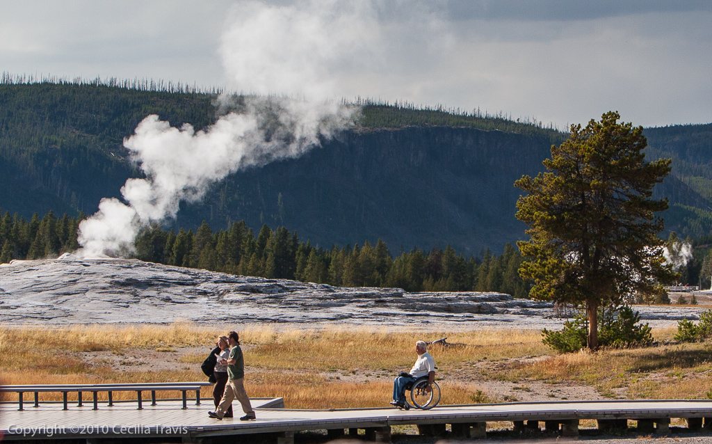
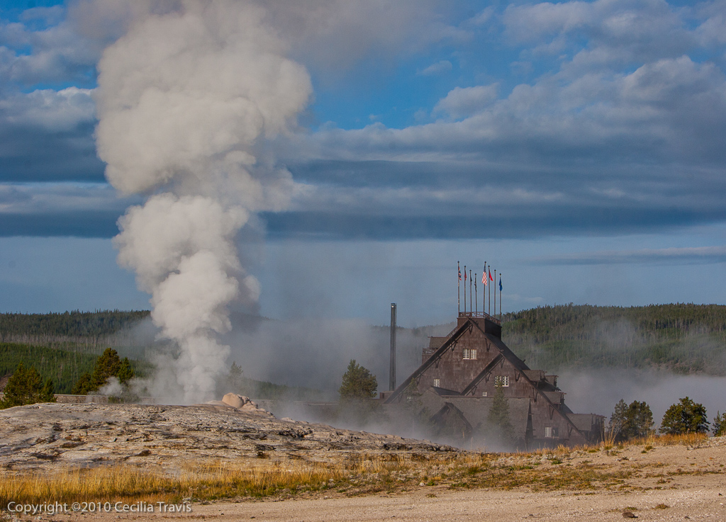
Anenome Geyser, Old Faithful Geyser and Old Faithful Inn, in background. Yellowstone National ParkVisitors near Old Faithful, Yellowstone National Park
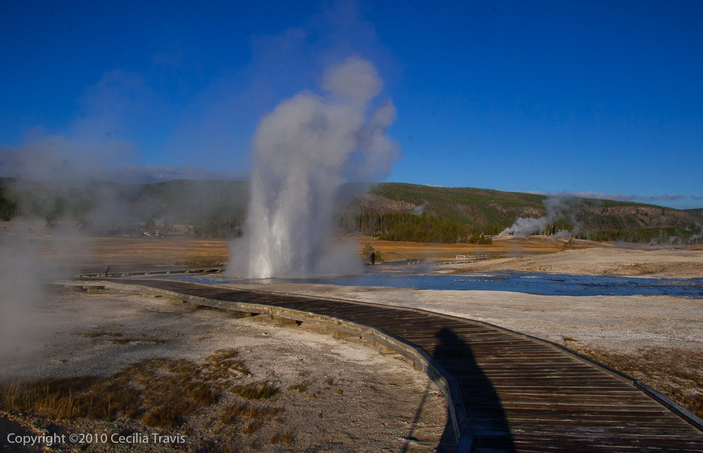
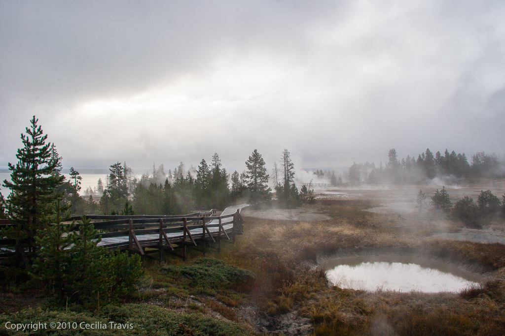
Mammoth Hot Springs. There are accessible boardwalk from which you can view the Mammoth Hot Springs Terraces. Norris Geyser Basin and Area. There are boardwalks here, but you may need assistance. The lower section of the Artists Paintpots is wheelchair accessible. Old Faithful. There are accessible paved trails and boardwalks going to Old Faithful Geyser, Geyser Hill, and Castle Geyser
Old Faithful Geyser & Old Faithful Inn from accessible boardwalk, Yellowstone National Park WYPlume Geyser from wheelchair accessible boardwalk, Yellowstone National Park, WY
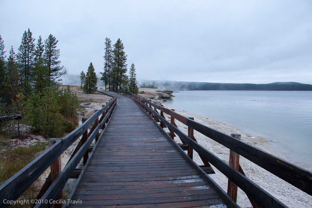
West Thumb Geyser Area. You may require some assistance on these boardwalks, which are by Yellowstone Lake.
Accessible Boardwalk at West Thumb Geyser Basin, Yellowstone National Park, WYWheelchair Accessible Boardwalk by Lake Yellowstone, Yellowstone National Park WY
Fishing Bridge Area. There is an accessible trail to the Mud Volcano, 6 miles north of Fishing Bridge.
Grand Canyon of the Yellowstone River. There are a number of accessible trails to overlooks. See the map in the Accessibility Guide.