Turtle River State Park
“Turtle River State Park is located in a beautiful, wooded valley along the meandering Turtle River. The park features year-round recreational activities, including camping, picnicking, hiking, mountain biking, cross-country skiing and sledding. ”
Here is the Park website. Map Phone 701-795-3180
There are no ADA compliant trails in Turtle River State Park, but Erika Kolbow suggests
![]() Fisher Trail [0.65 mile] as “the most accessible for elderly folks. They are more than welcome to walk the roadways and such too. Many of our roads go through the same habitats as our trails.”
Fisher Trail [0.65 mile] as “the most accessible for elderly folks. They are more than welcome to walk the roadways and such too. Many of our roads go through the same habitats as our trails.”
Category: North Dakota State
Fort Ransom State Park
Fort Ransom State Park
Here is the Park website. Map Phone 701-973-4331.
Thanks to Park Interpreter Victoria Silva for the following information: “Here at Fort Ransom State Park there are really only 2 trails that are flat, moderate, and have decent sized paths. We are in the Sheyenne River Valley, so a lot of the trails climb up and out and then back down into the valley which makes them unsuitable for easy trail users…….
![]() Our Little Twig Trail is .94-miles and is our easiest trail in the park, as well as being a guided interpretive trail with pamphlets that can be picked up at the trailhead and followed with corresponding letter posts that are found along the trail. It goes over a couple of scenic bridges and is primarily a dirt path. People have taken strollers and motorized scooters/wheelchairs on it, but it is not made for them so it is not the easiest trail…..
Our Little Twig Trail is .94-miles and is our easiest trail in the park, as well as being a guided interpretive trail with pamphlets that can be picked up at the trailhead and followed with corresponding letter posts that are found along the trail. It goes over a couple of scenic bridges and is primarily a dirt path. People have taken strollers and motorized scooters/wheelchairs on it, but it is not made for them so it is not the easiest trail…..
![]() Our North Country Trail is 1.35-miles one way and is a very flat trail with a big grass mowed path. It is a longer trail, especially with coming back, but it offers no challenge in regards to incline.”
Our North Country Trail is 1.35-miles one way and is a very flat trail with a big grass mowed path. It is a longer trail, especially with coming back, but it offers no challenge in regards to incline.”
Cross Ranch State Park
Cross Ranch State Park
“Situated along the west bank of the Missouri River, the 589-acre Cross Ranch State Park and adjacent 6,000-acre Cross Ranch Nature Preserve are one of the few areas in North Dakota to offer a true primitive outdoor experience.”
Here is the Park website. Map Phone 701-794-3731
![]() Matah “River” Trail: “This 2.9-mile trail begins at the Visitor Center and loops around the park’s main use areas. Along the river, interpretive signs describe the history, wildlife and geology of the area. The Matah Trail Self Guided Loop is the innermost loop covering 1.4 miles and takes up to an hour and a half to hike. Self-guided brochures are available at the trailhead or Visitor Center.” Thank you, Stephanie Heklowski for the following: “Our Matah Trail is wide and an easy walking trail, it remains pretty flat the whole time. For wheelchair accessibility it is probably not the greatest. We have a lot of elderly people that do come out here to walk the trail but they usually just do part of it. As a whole the trail would take about an hour to walk at a decent pace.”
Matah “River” Trail: “This 2.9-mile trail begins at the Visitor Center and loops around the park’s main use areas. Along the river, interpretive signs describe the history, wildlife and geology of the area. The Matah Trail Self Guided Loop is the innermost loop covering 1.4 miles and takes up to an hour and a half to hike. Self-guided brochures are available at the trailhead or Visitor Center.” Thank you, Stephanie Heklowski for the following: “Our Matah Trail is wide and an easy walking trail, it remains pretty flat the whole time. For wheelchair accessibility it is probably not the greatest. We have a lot of elderly people that do come out here to walk the trail but they usually just do part of it. As a whole the trail would take about an hour to walk at a decent pace.”
– North Dakota State Parks
North Dakota State Parks require either a $5 daily entry fee per vehicle or the $25 North Dakota State Parks annual pass.
Lake Metigoshe State Park
Lake Metigoshe State Park
“…..the lake is noted for its northern pike, walleye and perch. The rolling hills, aspen forests and small lakes attract nature and photography lovers to the area….” ” The Old Oak Trail, a National Recreation Trail, is found within the park boundaries. “
Here is the Park website. Map Trails For information call 701-263-4651.
![]() ? Thanks to Amy Schimetz for the following: [see the Map] “We have multi-use trails (red) that are in most places 12+ feet wide, whereas the Old Oak/Hemerick Trails are much narrower, only a few feet wide, comparable to a glorified game trail. The multi-use trails are grass-covered and can be quite uneven, having dips and low-lying areas which would be hazards. The Old Oak and the Hemerick Trails looks is a dirt path having dips, exposed tree roots in places, areas where trail is close to a cliff/drop-off, etc. All of our trails here at the park have portions that, in our opinion, would be flat and gently sloping but further down the trail is steeper. There is no one trail that we would suggest over the other due to the slopes and uneven ground.”
? Thanks to Amy Schimetz for the following: [see the Map] “We have multi-use trails (red) that are in most places 12+ feet wide, whereas the Old Oak/Hemerick Trails are much narrower, only a few feet wide, comparable to a glorified game trail. The multi-use trails are grass-covered and can be quite uneven, having dips and low-lying areas which would be hazards. The Old Oak and the Hemerick Trails looks is a dirt path having dips, exposed tree roots in places, areas where trail is close to a cliff/drop-off, etc. All of our trails here at the park have portions that, in our opinion, would be flat and gently sloping but further down the trail is steeper. There is no one trail that we would suggest over the other due to the slopes and uneven ground.”
“We are currently researching what it would take to make the Old Oak Trail, or a portion of it, handicap accessible. “
Lewis and Clark State Park
Lewis and Clark State Park
Lewis and Clark State Park is on one of the upper bays of Lake Sakakawea. “The park features miles of shoreline with picturesque views of towering buttes and rolling hills, that provide a rugged backdrop for the park. “Here is the Park website. Map Phone 701-859-3071
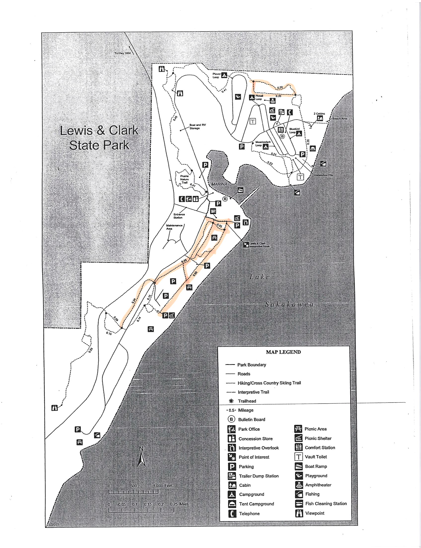
![]() Thanks to Assistant Park Manager Katie Ogden for this description: “We do have several trails along our shoreline that are wider and that are more level. I would recommend utilizing the trails in the west end of the park along the shoreline or the loop [northeast] east of the parks campgrounds.” …….”I have included a [ Map of Recommended Trails ] that has several highlighted options that I feel would accommodate the needs of your website and viewers. The trails in the west end of the park are truly beautiful and give you a wonderful panoramic of the Badlands and of Lake Sakakawea”. ………” We have a wide range of wildlife that can be seen from Pheasant, Grouse, Hungarian Partridge, Wild Turkey, Mule Deer, Whitetail Deer, Raccoon, Coyote, and various Song Birds.”
Thanks to Assistant Park Manager Katie Ogden for this description: “We do have several trails along our shoreline that are wider and that are more level. I would recommend utilizing the trails in the west end of the park along the shoreline or the loop [northeast] east of the parks campgrounds.” …….”I have included a [ Map of Recommended Trails ] that has several highlighted options that I feel would accommodate the needs of your website and viewers. The trails in the west end of the park are truly beautiful and give you a wonderful panoramic of the Badlands and of Lake Sakakawea”. ………” We have a wide range of wildlife that can be seen from Pheasant, Grouse, Hungarian Partridge, Wild Turkey, Mule Deer, Whitetail Deer, Raccoon, Coyote, and various Song Birds.”