Sesquicentennial State Park
Sesquicentennial State Park, affectionately known to locals as “Sesqui,” is a spacious, green getaway in the heart of the Sandhills region.
Here is the Park website . Phone 803-788-2706 Map Trail Map Brochure Trails
![]() Sandhills Hiking Trail 2 miles “This resurfaced and stroller-friendly trail circles the park’s 30-acre lake. Hikers, bikers and joggers will enjoy the sights and sounds of the Sandhills as they venture into the forest and through wetlands on boardwalks.”
Sandhills Hiking Trail 2 miles “This resurfaced and stroller-friendly trail circles the park’s 30-acre lake. Hikers, bikers and joggers will enjoy the sights and sounds of the Sandhills as they venture into the forest and through wetlands on boardwalks.”
![]() ? Loop Trail 3.5 miles “This multi-use trail uses an existing roadbed great for joggers, hikers and bikers. See a diverse array of plants and wildlife as you circle through the park’s forests and wetlands. USE CAUTION! Part of this trail is open to vehicles.”
? Loop Trail 3.5 miles “This multi-use trail uses an existing roadbed great for joggers, hikers and bikers. See a diverse array of plants and wildlife as you circle through the park’s forests and wetlands. USE CAUTION! Part of this trail is open to vehicles.”
![]() ? Jackson Creek Nature Trail 0.5 mile “This trail is a short loop through a bottomland forest area, upward into an open pine habitat and ending with a scenic view of Centennial Lake. There are interpretive signs to help you learn about the unique plants and animals that call Sesqui home”
? Jackson Creek Nature Trail 0.5 mile “This trail is a short loop through a bottomland forest area, upward into an open pine habitat and ending with a scenic view of Centennial Lake. There are interpretive signs to help you learn about the unique plants and animals that call Sesqui home”
Category: South Carolina State
Aiken State Park
Aiken State Park
Aiken State Park, in southwest Carolina sits on 1.7 miles of the Edisto River, North America’s longest free-flowing, blackwater river.
Here is the Park website. Trails Map Brochure Phone 803-649-2857
![]() Jungle Nature Trail 3 miles “level, easy-to-follow, 3-mile boardwalk and dirt turf loop through tropical-looking wetlands, and mixed pine and hardwood forest.”
Jungle Nature Trail 3 miles “level, easy-to-follow, 3-mile boardwalk and dirt turf loop through tropical-looking wetlands, and mixed pine and hardwood forest.”
Cheraw State Park
Cheraw State Park
The Park consists of 7361acres of parkland – much of which is covered in tall pines, and a 360 acre lake.
Here is the Park website. Phone 843-537-9656 Park Map Trail Map Brochure Trails
Thank you to Rhonda Griffith for information about the ease of these trails.
![]() Lake Juniper Boardwalk Trail 0.5 mile “runs alongside of Lake Juniper. Along the way you can see flowers, turtles and other local wildlife on the lake. The boardwalk continues to the spill way where our dam is located. There are some tree roots that might make for a bumpy ride but the short path to the water way is pretty. We call it a waterfall, but it is a manmade spill way for the dam.”
Lake Juniper Boardwalk Trail 0.5 mile “runs alongside of Lake Juniper. Along the way you can see flowers, turtles and other local wildlife on the lake. The boardwalk continues to the spill way where our dam is located. There are some tree roots that might make for a bumpy ride but the short path to the water way is pretty. We call it a waterfall, but it is a manmade spill way for the dam.”
![]() Cheraw Nature Trail and Turkey Oak Trail. Ms. Griffith says they are ADA, but may be bumpy. The Cheraw Nature Trail “is an easy 1.9-mile walk, which is the inner loop of the larger 2.6-mile Turkey Oak Trail” …both are… “a pleasant walk through a very dense forest of longleaf pine, blackjack oak, turkey oak, hickory trees, ……native irises called Blue Flags in the spring, and rose pogonia orchids in the summer. ” You may also see “…. lizards, deer, snakes, and a vast assortment of birds. A short spur trail offers a chance for you to see the rare red cockaded woodpecker. If you chose to continue on the Turkey Oak Trail, you will enter a cypress swamp as you approach Lake Juniper, where you may see waterfowl such as ducks, egrets, geese, and pied billed grebe. You may also be treated to a wide array of raptors such as bald eagles, ospreys, red-tailed hawks, northern harriers, and Mississippi kites.”
Cheraw Nature Trail and Turkey Oak Trail. Ms. Griffith says they are ADA, but may be bumpy. The Cheraw Nature Trail “is an easy 1.9-mile walk, which is the inner loop of the larger 2.6-mile Turkey Oak Trail” …both are… “a pleasant walk through a very dense forest of longleaf pine, blackjack oak, turkey oak, hickory trees, ……native irises called Blue Flags in the spring, and rose pogonia orchids in the summer. ” You may also see “…. lizards, deer, snakes, and a vast assortment of birds. A short spur trail offers a chance for you to see the rare red cockaded woodpecker. If you chose to continue on the Turkey Oak Trail, you will enter a cypress swamp as you approach Lake Juniper, where you may see waterfowl such as ducks, egrets, geese, and pied billed grebe. You may also be treated to a wide array of raptors such as bald eagles, ospreys, red-tailed hawks, northern harriers, and Mississippi kites.”
Poinsett State Park
Poinsett State Park
Poinsett State Park is in the “mountains of the midlands,” a mixed ecosystem with a high degree of biodiversity.
Here is the Park website. Phone: 803-494-8177 Map Trail Map Trail and Topo Map Brochure
![]() ?? Scout Trail 1.9 miles connects to the Wateree Passage of the Palmetto Trail. The first part (maybe 0.5 mile) , along the Palmetto Trail, appears to be pretty flat. See description under Manchester State Forest. The Park describes all its trails as “moderate”, but tripleblaze.com describes the Scout Trail as “easy” and sctrails.net says the trail is “moderately difficult”.
?? Scout Trail 1.9 miles connects to the Wateree Passage of the Palmetto Trail. The first part (maybe 0.5 mile) , along the Palmetto Trail, appears to be pretty flat. See description under Manchester State Forest. The Park describes all its trails as “moderate”, but tripleblaze.com describes the Scout Trail as “easy” and sctrails.net says the trail is “moderately difficult”.
Manchester State Forest
Manchester State Forest
Manchester State Forest is “approximately 28,675 acres of mixed pine and hardwood species native to the midlands of South Carolina. Soil type is light sand, interspersed with swamps and bays.”
Trails Map Phone 803-494-8196 Here is their website.
![]() ? Wateree Passage of the Palmetto Trail The first 2.25 miles of this 7.2 mile trail sound doable, but better call first. Manager J Map You can start from Poinsett State Park on the Scout Nature Trail. Read this review from tripleblaze.com for information and a caution about two other starting points. From Carolina Hiking
? Wateree Passage of the Palmetto Trail The first 2.25 miles of this 7.2 mile trail sound doable, but better call first. Manager J Map You can start from Poinsett State Park on the Scout Nature Trail. Read this review from tripleblaze.com for information and a caution about two other starting points. From Carolina Hiking
Harbison State Forest
Harbison State Forest
Bounded along its northeastern edge by the Broad River, Harbison Environmental Education Forest encompasses 2,137 acres of forestland only nine miles from downtown Columbia.
Here is the Forest website. Phone 803-896-8897 Trail Guide and Map Photographs
![]() Learning Trail 0.9 mile is a short trail around the Education Center.
Learning Trail 0.9 mile is a short trail around the Education Center.
Edisto State Park
Edisto State Park
“Rich in Native American history, Edisto Beach on Edisto Island is one of four oceanfront state parks in South Carolina.”
Here is their website. Phone 843-869-2156 Map & Trails Brochure
From the staff at Edisto Beach: “All of our trails, except for the Forest Loop Trail, were designed to be ADA-Accessible. Our trails were built with a nice, hard packed sand that makes for easy walking or movement in a wheelchair. The trails are also very flat and feature only minimal gains in elevation. They are also very wide and easy to navigate due to the placement of trail markers at each intersection. The bridges over Scott Creek were also designed to accommodate the passage of wheelchairs, so you should have no problems with them.”
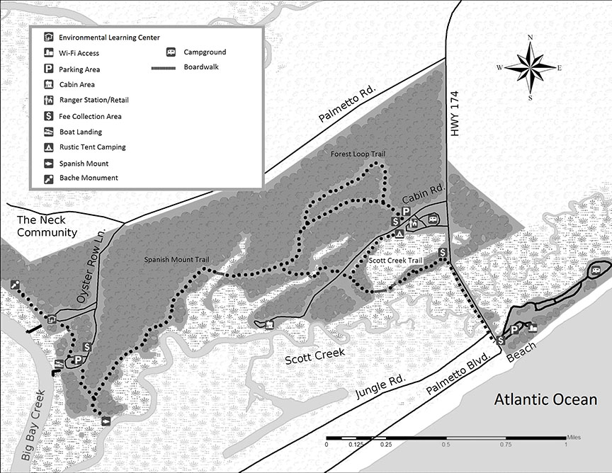
![]() Spanish Mount Trail 1.7 miles “One of the earliest Native American shell mound sites in South Carolina can be found at the western terminus of the Spanish Mount Trail.”
Spanish Mount Trail 1.7 miles “One of the earliest Native American shell mound sites in South Carolina can be found at the western terminus of the Spanish Mount Trail.”
![]() Scott Creek Trails 0.7 miles “..takes one through the maritime forest offering views of the marsh from three boardwalks. ”
Scott Creek Trails 0.7 miles “..takes one through the maritime forest offering views of the marsh from three boardwalks. ”
![]() Big Bay Trail 0.4 miles “This short trail will take you from the Education Center through the boat ramp parking area to the Spanish Mount. ”
Big Bay Trail 0.4 miles “This short trail will take you from the Education Center through the boat ramp parking area to the Spanish Mount. ”
![]() Campground Trail 0.3 miles …”will take you from the Education Center through the boat ramp parking area to the Spanish Mount.”
Campground Trail 0.3 miles …”will take you from the Education Center through the boat ramp parking area to the Spanish Mount.”
![]() Edisto Bike Trail 0.4 miles “runs along the paved causeway leading to the beach area of the park and to the Town of Edisto. From the intersection of the Scott Creek Trail and the Edisto Bike Trail, it is an easy 0.4 miles to the beach.”
Edisto Bike Trail 0.4 miles “runs along the paved causeway leading to the beach area of the park and to the Town of Edisto. From the intersection of the Scott Creek Trail and the Edisto Bike Trail, it is an easy 0.4 miles to the beach.”
South Carolina State Parks Guide
South Carolina State Parks Guide, produced by the Department of Parks, Recreation & Tourism, is a pretty thorough guide to the 47 state parks. However, you still need to contact each park individually to learn about accessibility.