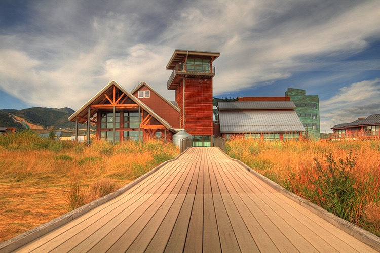
Swaner EcoCenter

Swaner EcoCenter
“The Swaner Preserve and EcoCenter is a 1,200 acre nature Preserve ….with interactive exhibits about the surrounding environment. … Visit the EcoCenter to learn more about our wetland ecosystem and the 10 miles of trails to explore!”
Here is the Center website.   Utah State University 435-649-1767  Preserve and Trails
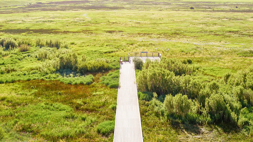
Wheelchair AccessibleLeslie, who answered my inquiry (and provided the photos) writes, “The EcoCenter and the pier going out onto the preserve are wheelchair accessible. However, in the winter the pier is covered with snow for snowshoeing.  I would say summer and fall would be the best times for elderly and people with wheelchairs to visit.”  

Accessible boardwalk path at Swaner Preserve and EcoCenter USU
© Swaner EcoCenter
Wheelchair accessible pier walking path at Swaner EcoCenter, Utah State University
Wheelchair accessible walking pier path Swaner EcoCenter, Utah State University© Swaner EcoCenter

Robert N. Hasenyager Great Salt Lake Nature Center

Robert N. Hasenyager Great Salt Lake Nature Reserve
The Reserve is located along the southeast shore of the Great Salt Lake, adjacent to the Utah Division of Wildlife Resources’ Farmington Bay Waterfowl Management Area (WMA).  The new (2019) George S. and Dolores Doré Eccles Wildlife Education Center at Farmington Bay  is on the  Reserve. The Center and trails provide “…. a gateway to the remarkable Great Salt Lake wetlands. ”
Here is the Eccles Center website.    Phone 801-451-5536.
Wheelchair AccessibleFarmington Creek Trail 1.5 miles ADA compliant. The “trail loops through the wetlands of Farmington Bay with several side trails. The trail features a 1700-foot-long boardwalk with a bridge over Farmington Creek, a long bridge across a large pond, and a winding boardwalk through a delightful marsh filled with birds of many kinds.”

Snow Canyon State Park

Snow Canyon State Park
“Explore the trails and dunes of beautiful Snow Canyon ….. Camp in the peaceful campground surrounded by ancient lava flows and red Navajo sandstone.”
Here is the Park website.    Brochure & Trail Map   Overview Map  Phone  435-628-2255
Wheelchair AccessibleWhiptail Trail  6 miles. “Level with some slopes. Accessible to people with disabilities. Tucked along the canyon bottom, this paved trail is suitable for walking, jogging, and biking.”
Jenny’s Canyon 0.5 mile, Johnson Canyon 2 miles, Pioneer Names 0.5 mile, West Canyon Road 8 miles, and Sand Dunes 0.5 mile are trails rated as easy with some slopes and/or steps.  Check with the Visitor Center to see if some of them would work for you.

Kodachrome Basin State Park

Kodachrome Basin State Park
“67 monolithic stone spires, called sedimentary pipes, accentuate multihued sandstone layers that reveal 180 million years of geologic time.  The color and beauty found here prompted a National Geographic Society expedition to name the area Kodachrome…”
Here is the Park website.   Phone 435-679-8562  Brochure & Trails Map
Grand Parade Trail 1.5 miles is easy, but check first to be sure it is suitable for you.
Wheelchair AccessibleNature Trail  0.5 miles hard surface interpretive trail.

Historic Union Pacific Rail Trail

Historic Union Pacific Rail Trail
“Weaving its way from Park City to Echo Reservoir, this 28-mile, non-motorized trail provides a close-up view of area wildlife and wildflowers.”
Here is the Trail website.   Phone 435-649-6839  Map
Wheelchair AccessibleThis rail trail is 28 miles following interstate 80 from Park City to Echo Reservoir.  It is mostly gravel, but there are 3 miles north from Park City and a 0.5 section in Wanship that are asphalt and suitable for wheelchairs.   TrailLink’s description

Fremont Indian State Park

Fremont Indian State Park
Discover artifacts, petroglyphs, and pictographs left behind by the Fremont Indians. This museum preserves treasures from the largest known Fremont Indian village  site. “Hike on paths that lead you up close to Rock art panels left by the Fremont people. “
Here is the Park website.   Phone 4335-527-4631  Brochure
Wheelchair AccessibleParade of Rock Art  0.4 miles paved interpretive trail

Dead Horse Point State Park

Dead Horse Point State Park
“From the prominence of Dead Horse Point, 2,000 feet above a gooseneck in the Colorado River, an ever-changing landscape unfurls. Immense vertical cliffs meet with canyons carved by ice, water, and wind creating a visual masterpiece.”
Here is the Park website.  Visitor Center phone 435-259-2614  Map  Trail Map
Brochure  Hiking
Wheelchair AccessibleOverlook Trail  200′ one way.  “…a short paved pathway leads to breathtaking views of the Colorado River and adjacent canyon country some 2,000 feet below.”
Wheelchair AccessibleVisitor Center Trail  1/8 mile round trip. “The paved path just outside the Visitor Center offers great views of the basin to the east, the La Sal Mountains and Chimney Rock.”  There are eight trail-side exhibits.
The East Rim Trail System  1.5-2 miles  “Aside from a short hill a quarter mile from the visitor center, this trail is predominately flat. ”
The Colorado River Overlook  1 mile.

Antelope Island State Park

Antelope Island State Park
The park offers “spectacular views of lake and island scenery.”  There are sandy beaches and you can “…take a dip in the lake’s salty waters or step back in time with a visit to the Historic Fielding Garr Ranch. Antelope Island is home to free-ranging bison, mule deer, bighorn sheep, pronghorn (antelope), and many other desert animals. Millions of birds congregate along the shores surrounding the island…”
 Here is the Park website.   Trails Map  Brochure   Utah Travel Secrets trail guide
Headquarters phone 801-649-5742,  Visitor Center Phone 801-725-9263
Lakeside Trail  2.8 miles one way. “An easy hike”   that  “follows a nicely maintained gravel  path” with elevation gain of only 69′.
Mountain View Trail is 11.38 miles one way and can be accessed via four parking areas.  It follows the east shore of the island.  “Wetlands and wildlife are abundant on the trail.”