Sequoia & Kings Canyon National Parks

Sequoia & Kings Canyon National Parks
The adjacent Sequoia and Kings Canyon National Parks in the southern Sierra Nevada of California have some accessible and easy trails.    The parks include high mountains, rugged foothills, deep canyons, marble caverns, and the world’s largest trees.  Elevations range from 1,300′ in the foothills to 14,491′ at the  summit of Mt. Whitney.  Much of the parks area is designated wilderness.  The two parks are administered together by the National Park Service.  Thank you Gary Rogers for bringing these parks to my attention.

There are five visitor centers and a museum. Two of the visitor centers, Foothills and Kings Canyon, and the museum are open year around.
Here is the Parks’ website.   Park phone 559-565-3341

Cedar Grove area trails
Wheelchair AccessibleZumwalt Meadow 1.5-mile trail, some of it boardwalk.  The trail “…passes high granite walls, lush meadows, and the Kings River.”  Parts of this trail were washed out in early 2017, making it more difficult.  Check with the visitor center.
Wheelchair AccessibleRoaring River Falls  paved  “Relatively accessible”  “…A very short, shady walk to a powerful waterfall rushing through a granite chute.”
?  Mist Falls 3 of the first 4 miles to the falls are “relatively flat”  but the last mile to the falls rises 600″.
Giant Forest and Lodgepole trails
Wheelchair AccessibleGeneral Sherman Tree.  There is handicapped parking and an accessible trail two miles north of the Giant Forest Museum on the Generals Highway.   The main trail is only 0.5 mile, but includes some stairs.
Wheelchair AccessibleBig Trees Trail 0.66 mile paved loop starting at Giant Forest Museum.

Grant Grove trails
Wheelchair AccessibleGeneral Grant Tree Trail  0.33 mile paved. Trail to one of the world’s largest living trees.
North Grove Loop   1.5 mile through “…quiet walk past meadows and creeks, through mixed conifer and sequoia forest.”
 

Inyo National Forest

Inyo National Forest
Inyo National Forest in the Eastern Sierra of California has some easy and some accessible trails and boardwalks such as the Nunatak Tioga Tarns Trail and the Convict Lake Loop Trail.  Thanks to Debra Schweizer for letting me know about them.  The 1,903,381 acre Inyo National Forest includes many of California’s iconic locations such as Mt. Whitney, Mono Lake, Mammoth Lakes, the John Muir Wilderness, and the Ancient Bristlecone Pine Forest.
Phone 760-873-2400  Here is their website.    Visitor Guide

Mono Lake Ranger District
Wheelchair Accessible?  Nunatak Tioga Tarns Trail  0.5 mile  There are interpretive signs along this trail.  Ms Schweizer writes that it may have been ADA compliant when it was originally built but has not been maintained.  She has seen wheelchair users on it, but they had assistance.
Mono Lake Boardwalk, South Tufa  0.7 mile easy boardwalk through the tufas.  From the photos it looks narrow for wheelchairs, but call the Visitor Center for information  760-647-3044   See also Mono Lake State Natural Reserve under the State listings on this page.

Mammoth Ranger District
Wheelchair AccessibleConvict Lake East Shore Trail   a short paved nature trail from the outflow of Convict Lake  to the picnic area at the base of Mt. Morrison.
Wheelchair AccessibleMs Schweizer mentions the bike trails at Mammoth Lakes area. Here is a link to descriptions of these paved, “family friendly” biking trails.

White Mountain Ranger District.
Wheelchair AccessibleSchulman Grove Visitor Center in the Ancient Bristlecone Pine Forest.  Ms Schweizer writes that there is a short boardwalk that gives access to the visitor center and has displays about the ancient trees.

Know more about Inyo National Forest?
Have you visited this location and know of more accessible or easy trails?  Is any of the information given here incorrect?  If so, please contact me using the form to the left and let me know what should be changed or added so I can update this post.

Lassen Volcanic National Park

Lassen Volcanic National Park
Lassen Volcanic National Park has a paved accessible interpretive trail.  The  hydrothermal features in Lassen Volcanic National Park include “roaring fumaroles (steam and volcanic-gas vents), thumping mud pots, boiling pools, and steaming ground.”  There are jagged peaks, mountain lakes, and meadows of wildflowers.
Here is the accessibility page for Lassen Volcanic NP and here a PDF of their Accessibility Guide.   Map    Phone 530-595-4480   Here is the park website.

Wheelchair AccessibleThere is a half mile paved interpretive trail in the Devastated Area.  The “easy, flat nature trail loops around a small section of the Devastated Area. Displays placed along the way explain various features of this area, flattened by the eruptions of Mount Lassen between 1914 and 1917. Excellent views of Lassen itself can be seen all along the trail as well.”

Know more about Lassen Volcanic National Park?
Have you visited this location and know of more accessible or easy trails?  Is any of the information given here incorrect?  If so, please contact me using the form to the left and let me know what should be changed or added so I can update this post.

Piedras Blancas Light Station

Piedras Blancas Light Station
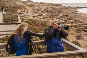
The beaches near the Piedras Blancas lighthouse, north of San Simeon, California attract thousands of elephant seals.
Wheelchair AccessibleThere are accessible boardwalks from which you can see and photograph the seals.  The site is governed by the Bureau of Land Management.  There is no fee for parking and viewing the seals.  Here are reviews from Yelp and Trip Advisor.   Phone for Friends of the Elephant Seal 805-924-1628      Website

Thank you Cathy and Gordon Illg for the photograph!

Photographing elephant seals from ADA wheelchair accessible boardwalk at Piedras Blancas Point
Photographing elephant seals from ADA wheelchair accessible boardwalk at Piedras Blancas Point © Cathy & Gordon Illg

Plumas National Forest

Plumas National Forest
The Plumas National Forest northeast of Chico, California has many easy trails and a couple of accessible ones.  However, remember that a trail designated as “easy” may not be easy enough for you.  Visitors to the Plumas National Forest enjoy its “many streams and lakes, beautiful deep canyons, rich mountain valleys, meadows, and lofty peaks.”   The Forest is divided into three Ranger Districts.  Call before heading out to determine trail conditions.
Phone 530-283-2050  Here is the Forest website.

Beckwourth Ranger District  phone 530-836-2575  Trail Descriptions.
Fern Falls Overlook  0.1mile On the Gold Lake Hwy. The trail crosses Gray Eagle Creek and leads to a scenic overlook near Fern Falls.
Grassy Lake Trail 0.8 mile  leads past Grassy Lake and crosses Gray Eagle Creek.
Wheelchair AccessibleFrazier Falls 0.5 mile on the old Gold Lake road.  A paved trail leads to a fenced scenic overlook of the 176 foot tall Frazier Falls. ” Individuals in wheelchairs may need assistance. Wheelchair rating difficult”
Red Fir Nature Trail 0.5 mile on the Mills Peak Lookout road.  Signed trail interpreting the ecosystem within a red fir stand.
Wheelchair Accessible Big Cove Enabler 0.2 miles  Leads from Big Cove Campground to the lake.

Feather River Ranger District  Phone (530) 534-6500  Trail Descriptions
Big Bald Rock – 0.5 mile one way.  Near the town of Berry Creek.

Little North Fork 2 miles one way.  After the first 2 miles the trail becomes steep.  15 miles northeast of Brush Creek Work Center. The trail follows the Little North Fork River north towards the historic Robinson Mine but the trail no longer actually reaches Robinson Mine.

Mt. Hough Ranger District   Trail Descriptions

 Yellow Creek Trail 1.4 miles  Near the Ely Stamp Mill rest area, across from Belden, “…an enjoyable day hike that ends in a box canyon.”

Know more about Plumas National Forest?
Have you visited this location and know of more accessible or easy trails?  Is any of the information given here incorrect?  If so, please contact me using the form to the left and let me know what should be changed or added so I can update this post.

Mendocino Nat’l Forest

Mendocino National Forest
The Mendocino National Forest has a couple of accessible trails at Chico Seed Orchard. The Orchard produces plants for a wide variety of projects ranging from reforestation and mine reclamation to biological, chemical, and clinical research on anti-cancer drugs derived from plants.  The Mendocino is uncrossed by paved roads.  Its elevation goes from 750 feet in the Grindstone Creek Canyon in the Sacramento Valley foothills on the Forest’s eastern edge to the 8092 feet of South Yolla Bolly Mountain in the northern part of the Forest.
Accessible Recreation Possibilities    Phone 530-934-3316   Here is their website.

Chico Seed Orchard  
Wheelchair Accessible
Comanche Trail  1 mile loop  in “The 3/4 mile hard surface trail winds through mixed stands of mature trees with walk bridges crossing small stream beds.”
Wheelchair AccessibleSelf-guiding nature trail: 1 mile loop “meanders through a unique botanical area in Edgar Slough which has remnants of exotic species that were planted when this was a Plant Introduction Center.

Know more about Mendocino National Forest?
Have you visited this location and know of more accessible or easy trails?  Is any of the information given here incorrect?  If so, please contact me using the form to the left and let me know what should be changed or added so I can update this post.

San Bernardino Nat’l Forest

San Bernardino National Forest
The San Bernardino National Forest in Southern California has many easy and a few accessible trails.  The  823,816 acre Forest includes five wilderness areas. There are district Ranger Offices at Fawnskin, Idyllwild, and Lytle Creek.   Baron Flats and Mill Creek have Visitor Centers.  Elevation ranges from 2,000′ to 11,499′.
Here is the Forest website.    Headquarters are in San Bernardino, phone  909-382-2600   Visitors Guide   Accessibility

San Jacinto Ranger District, Idyllwild   phone 909-382-2921
Ernie Maxwell Scenic Trail – 2.6 mile trail leaves from Humber Park. The trail starts at 6100 ft. elevation and crosses streams as it descends 600 ft.  It is rated easy, but may not be easy for you.  Call ahead to learn more.
Chaparral Neighborhood Trail 0.5 mile self guided nature trail.  Said to be easy, but check with the Ranger Station first.

Front Country Ranger District, Lytle Creek  phone 909-382-2851
Wheelchair AccessibleNative Plant Garden  paved walkways through different local plant communities.  No ADA rating, but this garden right behind the ranger station sounds likely.
Rio Monte Trail  2.5  miles “easy walk”  Starts at Barton Flats Visitor Center.  Check ahead 909-794-4861 to determine if this is easy enough for you.
Big Falls Trail  0.3 miles “easy walk”  The trail goes to the highest waterfall in Southern California.

Mountain Top Ranger District, Fawnskin  phone 909-382-2790
Lake Arrowhead area
Seeley Creek Trail  1 mile described as “gentle”.  Trail crossed the creek and ends at a waterfall.
Heaps Peak Arboretum Trail  0.7  mile loop  a self guided nature tour that is “easy for all ages”.
Wheelchair AccessibleTrail of the Phoenix  0.5 mile loop “designed and maintained to accommodate the needs of the visually and physically disabled.”
Big Bear Valley
Wheelchair AccessibleAlpine Pedal Path  2.5 miles one way asphalt path  “connects the Big Bear Discovery Center with the Cougar Crest Trailhead and a pathway along the North shore of Big Bear Lake”    “…this gentle trail has some magnificent views of the lake.”
Nature Discovery Trail 0.5 mile loop through the forest behind the Big Bear Discovery Center.
Woodland Trail  1.5 mile loop self guided interpretive trail

Champion Lodgepole Pine Trail 0.3 mile one way along a small stream, ending at one of the largest known Lodgepole pines in California.  You can continue another 0.4 mile on the Bluff Mesa Trail which is a “leisurely walk” through stands of Jeffrey Pine.

Know more about San Bernardino National Forest?
Have you visited this location and know of more accessible or easy trails?  Is any of the information given here incorrect?  If so, please contact me using the form to the left and let me know what should be changed or added so I can update this post.

Yosemite National Park

Yosemite National Park
The 1,200 square miles of  Yosemite National Park include impressive waterfalls,  deep valleys, grand meadows, ancient giant sequoias, and a vast wilderness area.
Here is the Park website.   Accessibility Guide  Phone  Park Headquarters  209-372-0200   Accessibility Coordinator 209‐379‐1035
Yosemite Valley     Here is a video of easy trails.
Wheelchair AccessibleLower Yosemite Falls Trail 1 mile paved  “Consider walking the loop in a clockwise direction for best views of Yosemite Falls. This eastern portion of this loop trail is wheelchair accessible (when not covered in ice or snow).”
Bridalveil Fall Trail 0.5 mile paved  The trail is considered too steep for wheelchairs.
Mirror Lake Trail 1 mile paved.  Be sure to go in the spring when there is a lake and not just a meadow.
Cook’s Meadow Loop  1 mile  “…short, easy walk offers stunning views of Yosemite Falls, Half Dome, Glacier Point, and Sentinel Rock.”
Wawona
Wawona Meadow Loop  3.5 miles

White Wolf
?  Lukens Lake from Tioga Road  1.6 miles round trip.  “The trail winds through a mixed conifer forest, then over a saddle and down to a small mountain lake surrounded by a meadow.”    Although this trail is rated “easy” you had better call first to learn about possible obstacles.
Tuolumne Meadows
Soda Springs and Parsons Lodge 1.5 miles   Described in trailmob.com  as “a great choice for hikers traveling with small children. ”

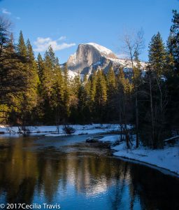
Half Dome seen from accessible road, Yosemite National Park, California
Half Dome, seen from accessible Sentinel Bridge, Yosemite National Park, CA

Golden Gate National Rec. Area

Golden Gate National Recreation Area
The park has many interesting sites to visit including Alcatraz Island, Muir Woods National Monument, Fort Point National Historic Site, the Marin Headlands,
Here is their website and their page regarding accessibility.    
Map and Brochure Phone 415-561-4700

Wheelchair Accessible

Muir Woods has an accessible boardwalk for several hundred feet to Founders Grove. “…past the boardwalk you will encounter an asphalt trail which is usable; however, it contains potholes and severe cracks due to heaving tree roots. As funding and resources allow, we will continue to replace the existing asphalt with an accessible raised boardwalk.”  Muir Woods Brochure is available in Braille.  Accessibility at Muir Woods.

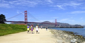
Wheelchair AccessibleThe photo is courtesy of Mark Hehir, who writes that San Francisco’s Crissy Field has “several handicap parking spots, and you have a wonderful view of the Golden Gate Bridge, and of Alcatraz Island.”

Wheelchair accessible path by Golden Gate Bridge from Crissy Field, San Francisco, CA
Wheelchair accessible path by Golden Gate Bridge from Crissy Field, San Francisco, CA ©Mark Hehir 2014