Texas has a number of trails with minimal obstacles. Some are very easy and others are wheelchair accessible. Here are just a few of them.
Most of the links given were found through Internet search, although a few have been recommended to me by other people who have been there. With your help, we can share our knowledge with disabled people everywhere and also increase awareness of the need for more accessibility. Please e-mail me with your suggestions using the form in the sidebar.
Federal
State
Local
Private
Miscellaneous
Federal
Balcones Canyonlands National Wildlife Refuge
“Within the refuge, old growth stands of mature Ashe juniper, low-growing shin oaks, grasslands and spring-fed creeks provide important habitat for many species unique to the Texas Hill Country. At least one-third of Texas’s threatened and endangered species live or move through this part of the Hill Country, the Edwards Plateau.”
Here is the Refuge website. Phone 512-339-9432 Map Trails
Warbler Vista Trail Map Doeskin Ranch Trail Map
 The only mention of accessibility on the refuge website is an accessible photo blind on Post Oak Creek Trail and an accessible sunset deck at Warbler Vista reached via the Ridgeline Trail. Both these trails are described as having “moderate” grades (5% to 8%) and “native” surfaces. There are numerous trails described as “gentle”.
? Pond and Prairie Trail at Doeskin Ranch is 0.38 mile and “gentle” with a cross slope of only 1.5. The surface is “native/paved”. Better call to learn where it is safe for you to go.Big Bend National Park
“Big Bend National Park is a geological marvel evidenced in sea fossils and dinosaur bones to volcanic dikes that mar the desert landscape. It’s a world of species diversity from the meandering river corridor that sidles across the desert floor to the sky island ridge tops that reach for the stars.” In addition to the accessible trails, there are about six day hikes described as “easy”. Check with the Park to be sure.
Here is the Park website. Phone 432-477-2251 Maps Maps of Chisos Basin and Rio Grande Village with trails. Accessibility
Panther Path 50 yard loop “self-guiding nature trail at Panther Junction, is rough, but level and useable by people in wheelchairs. An accompanying brochure explains Chihuahuan Desert plants.
Window View Trail 0.3 mile in the Chisos Basin “provides outstanding views of the window formation and the Chisos Mountains.”
 Rio Grande Village Nature Trail Boardwalk. 0.75 mile loop. “The first 100 yards is wheelchair accessible and crosses a boardwalk through a spring-fed wetland”. The trail is an “excellent place for observing birds and aquatic plants and animals.” There is a self-guiding booklet.
Chihuahuan Desert Nature Trail 0.5 mile round trip “On this easy desert stroll you will see remnants of human settlement and typical Chihuahuan Desert habitat. A shady oasis with cottonwood trees and tables at Dugout Wells provides a good area for picnicking and bird watching.”Big Thicket National Preserve
Big Thicket Preserve protects the incredible diversity of life in nine different ecosystems, from longleaf pine forests to cypress-lined bayous.
Here is the Preserve website. Phone 409-951-6800 Accessibility Map Trails
Quite a few of the trails at Big Thicket look as they might be easy walking, but call first to be sure.
? Kirby Nature Trail map This self-guided trail is not described on the website as wheelchair accessible, but is labeled so on the general park map.
Pitcher Plant Trail map 3/4 mile “…boardwalk through the savannah provides easy access for viewing several types of carnivorous plants.” The first 1/4 mile is accessible.
Sundew Trail Map 1.0 mile loop “…a great place to see birds and wildflowers.” The inner loop is accessible.Buffalo Lake National Wildlife Refuge
“Buffalo Lake National Wildlife Refuge contains some of the best remaining short grass prairie in the United States.”
“Walking trails, blinds and an 11-mile auto tour route offer many opportunities to get outside and enjoy the refuge.”
Here is the Refuge website. Phone 806-499-3382 Trails
 Prairie Dog Loop 0.25 miles ADA wheelchair accessibleCottonwood Hiking Trail 1.25 mile ADA wheelchair accessible
Guadalupe Mountains National Park
“Guadalupe Mountains National Park protects the world’s most extensive Permian fossil reef, the four highest peaks in Texas, an environmentally diverse collection of flora and fauna, and the stories of lives shaped through conflict, cooperation and survival.”
Here is the Park website. Accessibility Phone 915-828-3251 Map Brochure on Day Hikes
Pinery trail 0.7mile “paved trail leads to the ruins of a mid-1800s Butterfield stagecoach station and features exhibits about the plants of the Chihuahuan Desert.”
Manzanita Spring Trail 0.5 mile trail “leads to Manzanita Spring and through the orchard once belonging to the Smith family.”
? Indian Meadow Nature Trail 0.6 mile round-trip. Rated “easy”, but call first to be sure.Hagerman National Wildlife Refuge
Just 75 miles north of Dallas, the Refuge provides a variety of habitats for birds and wildlife. Earthen dikes create shallow marshes for waterfowl and farm fields provide 300 acres of wheat for wintering geese. Colorful wildflowers and prairie grasses provide seasonal food and shelter for wildlife. Bottomland hardwoods along the creeks attract a variety of wildlife including white-tailed deer, bobcats, river otters, turtles, and fox squirrels.
Here is the Refuge website. Trails Phone 903-786-2826. Be sure to call to learn about trail conditions after rain.
Harris Creek Trails – Crawfish Pond Loop. 1/3 mile of this trail and a photo blind are ADA accessible.
 ? Meadow Pond Trail is 5.7 mile round trip – you may want to walk just a part of it. It crosses a variety of habitats including shallow ponds, farm fields, forests, and bottomland hardwoods. The surface is gravel. Call to be sure there are no steps or other obstacles.
Padre Island National Seashore
“Padre Island National Seashore separates the Gulf of Mexico from the Laguna Madre, one of a few hypersaline lagoons in the world. The park protects 70 miles of coastline, dunes, prairies, and wind tidal flats teeming with life. ”
Here is the Seashore website. Phone 361-949-8068 Accessibility
There are five beach wheelchairs available for free for accessing Malaquite Beach.Santa Ana National Wildlife Refuge
Santa Ana National Wildlife Refuge lies along a juncture of two major migratory routes for many species of birds. “It is also at the northern-most point for many species whose range extends south into Central and South America. ……Though small in size, Santa Ana offers visitors an opportunity to see birds, butterflies and many other species not found anywhere else in the United States beyond deep South Texas.”
Here is the Refuge website. Phone 956-784-7500 Map Trails Map Accessibility
? The longest of the 12 walking trails at this refuge is just 2 miles. Call to find out if some are easy enough for you.
Tour loop 7 miles ADA compliant. “Accommodations are possible for wheelchair users on the tram (inquire at the Visitor Center).”
Chachalaca Trail 0.5 miles
State
Texas State Parks and Historic Sites with Wheelchair-Friendly Facilities
This list with links is a great source of information for wheelchair users. It includes fishing piers and boat ramps.Abilene State Park
“Come to the shady banks of Elm Creek, where large trees arch overhead and deer and other critters wander by. Just 16 miles southwest of Abilene, the park has a lake and fishing pond, a historic swimming pool, trails, camping and more.” There are six trails described as “easy” in addition to the ADA accessible Eagle trail.
Here is the Park website. Phone 325-572-3204 Brochure Map Trails Map
Eagle Trail to Buffalo Wallow Pond 1.5 mile on hard surface caliche. 0.5 mile of this trail is wheelchair accessible.
? There is a “…short Boardwalk to a wildlife viewing platform in the Day Use Area.”Bentsen-Rio Grande Valley State Park
As part of the World Birding Center, Bentsen-Rio Grande Valley State Park is a world-class destination for bird-watching. 358 species of birds have been recorded within the park’s boundaries.
Here is the Park website. Phone 956-584-9156 Map
Rio Grande Trail 1.8 miles loop. A .2 mile round trip takes you to the accessible two-story high Hawk Tower for a “bird’s-eye view of the canopy as well as a peek into Mexico.”
Kiskadee Trail 0.4 mile one wayGreen Jay Trail 0.3 mile one wayBrazos Bend State Park
Brazos Bend State Park includes 5,000 acres of bottomland and upland coastal prairie. …Woodlands include live-oak gallery forests and mixed bottomland hardwood forest” and there are ” several types of wetlands: swamps, lakes, marshes and short-lived ponds….” The park is about an hour from Houston.
Here is the Park website. Phone 979-553-5101 Trails Map
Creekfield Lake Nature Trail 0.5 mile paved trail in wetland. “This short, accessible trail makes it easy for you to see many different kinds of wildlife and features interpretive signs along the way.”Caddo Lake State Park
“Bald cypress trees draped with Spanish moss tower over the maze of bayous, sloughs and ponds of Caddo Lake.”
Here is the Park website. Phone 903-679-3351 Map Trails Map Brochure
Caddo Forest Trail 0.25 mile of the 0.91 mile trail is ADA compliant.Lake Somerville State Park
“Four units make up Lake Somerville State Park. Birch Creek Unit is on the north side of the lake, while Nails Creek Unit is on the southwest side. The 13-mile Lake Somerville Trailway connects the two units. Somerville Public Hunting Land is nearby, also on the lake. Birch Creek and Nails Creek offer access to the lake for fishing, boating, paddling and swimming. ”
Here is the Park website. Phone 979-535-7763 Trails Map
Honeybee Hill Trail at Birch Creek 0.44 mileFlag Pond Loop 1.67 miles. Call to be sure this trail is easy for you.Palo Duro Canyon State Park
“The second largest canyon in the country lies in the heart of the Texas Panhandle.” It offers a “a myriad of recreational opportunities, rich history and colorful geology.”
Here is the Park website.Phone 806-488-2227 Trails Map Facilities Map Brochure
Pioneer Nature trail 0.49 mile loop a “family-friendly trail that loops down to the river and back.”
Sunflower 1.17 one way. A “shady, family-friendly trail.”Paseo del Rio 2 miles round trip “suitable for all levels”.Sea Rim State Park
“Sea Rim State Park has 5.2 miles of Gulf shoreline and 4,000 acres of marshlands.”
Here is the Park website. Phone 409-917-2559 Trails Map
? Gambusia Marsh Nature Trail 0.75 miles and Dune Boardwalk 0.1 mile are both described as easy. However, there are no claims for accessibility so perhaps the boardwalks have steps or other obstacles. Call to find out.
Local
Armand Bayou Nature Center
“ABNC is the largest urban wilderness preserve in the U.S. with 2500 acres …. We are home to over 370 species of birds, mammals, reptiles and amphibians. There is a “”a boardwalk through the forest and marshes, live animal displays, educational signage, bison and prairie platforms, butterfly gardens and a 1800’s farm site.” There are” more than 5 miles of well maintained trails that provide .25 mile to 1.5 mile loops though ABNC’s stunning forest, prairie, marsh and natural bayou habitats which were once common in the Houston/Galveston area.”
Here is the Center website. Phone 281-474-2551 or 713-274-2688 Trail Map Yelp Reviews
Martyn Trail 1.3 miles dirt surfaceKarankawa Trail 1.38 miles dirt surfaceLady Bird Trail 1.5 miles dirt surface Short Loop Boardwalk This may be accessible, but the website does not say so. Call the Center to find out and to learn other trail conditions.City of Berne
Cibolo Nature Center & Farm
Cibolo is a “unique conservation model to protect our resources, study and learn from the natural world, teach and apply sustainable farming practices, and encourage the enjoyment and celebration of nature.” The Center is important habitat for a variety of flora and fauna found in habitats such as spring-fed marsh, tallgrass prairie, riparian forest and live oak savannah.
Here is their website. Phone 830-249-4616 Map and Trails
Marshland Trail 0.5 mileWoodlands Trail 0.5 mi. looks easy, but call to be sure of conditions.Fort Worth
Fort Worth Nature Center & Refuge
The Refuge encompasses 3,621 acres and includes over 20 miles of hiking trails in habitats including forests, prairies and wetlands.. It is a National Natural Landmark. There are a number of short trails that might be easy – call to find out.
Here is their website. Phone 817-392-7410 Map and Trails
Limestone Ledge Trail 0.21 mile paved nature trail “…great trail to hike during the spring months. This trail is blanketed with wildflowers..”
Marsh Boardwalk 0.16mile over wetlands.Fredericksburg
Fredericksburg Nature Center in Lady Bird Johnson Municipal Park
Phone (city hall) 830-997-7521 Map
Handicapped Accessible Trail 600 feet “….runs along a bluff overlooking the lower section of the Vista Loop Trail, passing the Butterfly Garden, the bird blind, and bird-feeding station.”Harris County
Jesse H. Jones Park & Nature Center, Humble
“Jesse H. Jones Park & Nature Center is a premier 312-acre Harris County Precinct 4 nature preserve open daily to visitors free of charge. The park features a variety of plant and wildlife species, white sand beaches along Spring Creek, swamps and sloughs with century-old cypress trees, and a pristine floodplain located in a hardwood and pine forest.”
Here is their website. Phone 281-446-8588 Trails Map
There are over eight miles of paved, handicap-friendly pedestrian trails and several unpaved primitive trails. Although the website does not give descriptions of the eleven or so trails in this park, the map states that “All trails are wheelchair accessible with the exception of the River Birch Trail”.Hood County
Acton Nature Center
“Trails will lead you around the center to view the natural pond filled with croaking toads. In a heavily shaded ravine you will find a large old Live Oak tree spreading its branches as if to welcome you in.”
Here is the Center’s website. Phone 817-326-6005 Trail Map Aerial Trail Map
Elizabeth Crockett Butterfly Trail 0.3 miles
Private
Cedar Ridge Preserve
Managed by Audubon Dallas, Cedar Ridge “is a natural habitat of 600 acres featuring about 9 miles of trails, native trees, grasses and wildflowers, butterfly gardens, limited picnic areas and wild mammals, birds, insects and reptiles” It is 20 minutes from downtown Dallas. Although there is only one wheelchair accessible trail, several others look as if they might be fairly easy. The scale of the trail profiles makes them look much steeper than they are. Call to learn more.
Here is the Preserve website. Phone 972-709-7784 Trail Map Trail Profile
Little Bluestem Trail 0.25 mile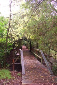
Bridge at Edith L. Moore Sanctuary
© Houston Audubon SocietyEdith L. Moore Sanctuary
“Maintained by the Houston Audubon Society, the sanctuary is 18 acres of hardwood and pine forest and freshwater habitats. The sanctuary ‘provides a special place to experience nature in our city.'”
Here is the Sanctuary website. Phone 713-932-1639 Map
Online Trail Guide.
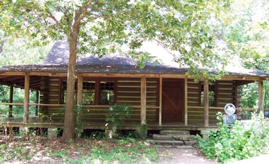
” The trails are well marked, evenly graded and easily traversed. There are both mulched and board-walked paths. The log cabin has wheel chair ramps and an accessible restroom facility. There are two trails that are not wheelchair-safe – these are the ‘bumpy trail’ on the north end of the property along Rummel Creek and ‘west bank trail’ on the east side of the pond.”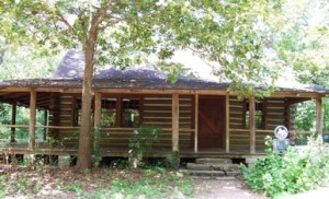
Edith L. Moore cabin, which is wheelchair accessible from the other side.
© Houston Audubon Society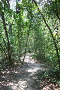
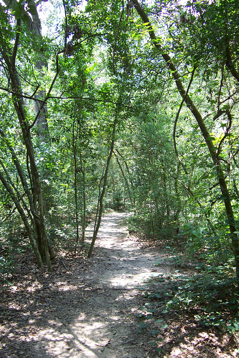
Path at Edith L. Moore Sanctuary
© Houston Audubon SocietyHeard Natural Science Museum and Wildlife Sanctuary
“Escape the concrete of the city and hike over 6.5 miles of self-guided or interpreted nature trails that wind though the diverse habitats of our 289-acre wildlife sanctuary, including tall grass prairie, bottomland hardwood and limestone escarpment. Take advantage of the opportunity to encounter many species of birds, insects and animals. ” This sanctuary is near McKinney.
Here is their website. Phone 972-562-5566 Trail Map
Wood Duck Trail 0.9 “…best view of the wetlands, partly shaded”Bluestem Trail 0.5 mile “…best view of the prairie, partly shaded”Laughlin Loop Trail 0.5 mile jogging stroller friendly, partly shaded”Houston Arboretum & Nature Center
“Located on the western edge of Memorial Park, the Houston Arboretum & Nature Center offers an escape from the hustle and bustle of city life and the opportunity to experience the natural world. This 155-acre non-profit urban nature sanctuary provides education about the natural environment to people of all ages.”
Here is their website. Phone 713.681.8433 Map Trails
 Palmetto Multi-sensory Trail 0.33 mile loop “…this trail offers many interpretative stops that educate visitors about the natural world here at the Arboretum.”
Alice Brown Loop/ Ravine Overlook 0.5 mile “...this short loop parallels the driveway and leads to a small pond. Along the way, be sure to stop at the Ravine Overlook Deck where you’ll have a bird’s eye view of the forest from the canopy above to a stream below.”
There are several other trails which look as if they might be easy walking. Call the center to learn more.Lower Colorado River Authority
The LCRA maintains more than 11,000 acres of parks along the Lower Colorado River.
Here is the website for the LCRA. LCRA Parks
McKinney Roughs Nature Park Phone 512-303-5073 Trail Map Trail Hotline 512-578-7427
Ridge Trail 0.6 mile “…an ADA trail along a box canyon, providing lovely views of the park and an easy excursion for families with children.”
“Other trails range from easy to challenging….” The trail guide does not say how easy the trails are, so call to plan where you can go.
Westcave Preserve Website Phone 830-825-3442 Map of Upland Trails
“Upland Trail is Wheelchair & Stroller Friendly from Parking Lot to the Ahrns Grove” Distance is not given, but it appears to be no more than about 300′.Miller Springs Nature Center
Miller Springs Nature Center is a 260 acre scenic natural area located between the Leon River and 110 foot high bluffs, immediately east of the Lake Belton Dam.
This area has been damaged by floods. Call ahead to be sure it is open and to check the condition of the trails. I have included a lot of trails marked as easy, but you should check first before heading out on them.
Here is the Center website. Phone at U.S. Army Engineers, Belton Dam 254-939-1829 or the Miller Springs Alliance 254-933-7487 Trails and Map
Rim Trail 0.7 mile “… affords wonderful views of the Leon River valley, the limestone wall of the new canyon carved by the 1992 flood and the mural wall. Wildflowers are plentiful anytime there is sufficient rainfall.”
Armadillo Trail 0.41 miles. “….level trail twists through pleasant mountain cedar forest through open meadows and over exposed limestone shelves, and forms a loop back to the Rim Trail.”
North Trail 0.38 mile “A beautiful trail takes you through upland forest and along a scenic limestone ledge with a great view showing prairie flowers and the mural wall. The southern part of the trail is handicapped accessible and provides access to many other trails via the walk across the spillway.”
Beaver Ponds Trail 0.73 mile “…wanders through the forest at the top of the lower bluff.” The trail makes several creek crossings – you might check with the Park to learn if there are obstacles for you.
South River Trail 1.4 miles Open to bikers, joggers and hikers. Goes through meadows, forest and prairie.
Prairie Loop 1.2 miles “….travels through prairie environments for more than half of its length. The southern and part of the western path meanders through lush forests and pleasant meadows. Just before sunset one often sees numbers of deer in the eastern areas.”
Old Forest Loop 0.44 mile Goes through undisturbed old forest growth.San Antonio Botanic Garden
“With something always new to see at the San Antonio Botanical Garden, each season brings a variety of color and texture in the plant world.” The 38 acre garden is accessible to visitors with disabilities.
Texas Native Trail area is on 11 acres and has more than 250 species of plants in plant communities characteristic of the Hill Country (Edwards Plateau), East Texas Pineywoods, and South Texas.
There is a Braille Trail planted to engage the senses of touch and smell. Thank you Marti Nodine for telling me about it.
Wheelchairs are available on a first-come basis at the front desk.
Map Phone 210-536-1400South Padre Island
South Padre Island is part of the World Birding Center. “The nature center offers more than 3,300 linear feet of boardwalk, five bird blinds, and a five story tower with spectacular views of the Laguna Madre, beaches and dunes of South Padre Island, The Gulf of Mexico and the South Padre Island skyline.” “Our board walks and wetlands will provide you with up-close viewing of spectacular wetland birds, migrating songbirds and the island’s dazzling butterfly population.”
Here is their website. Phone 956-761-6801 Map can be downloaded from the website.
According to David and Jan Dauphin on their very helpful site, “The Butterfly Garden, all Boardwalks, and everything on the inside are handicapped-accessible.”

Miscellaneous
Wheelchair Accessible Wildlife Viewing Sites in Texas – This includes state as well as federal areas.
The Houston Audubon Society is a great resource for information on accessible places in that area. Thank you, Betty H.
Nature For The Blind has a directory of Braille trails for almost every state in the US and for many other countries.
The Rails-to-Trails Conservancy lists wheelchair accessible trails in Texas.