Utah has a number of trails with minimal obstacles. Some are very easy and others are wheelchair accessible. Here are just a few of them.
Many of the links given were found through Internet search. Some places I have been able to visit and a few have been recommended to me by other people who have been there. With your help, we can share our knowledge with disabled people everywhere and also increase awareness of the need for more accessibility. Please e-mail me with your suggestions using the form in the sidebar.
Federal
State
Local
Private
Miscellaneous
Federal
Arches National Park
Arches National Park “…has over 2,000 natural stone arches, in addition to hundreds of soaring pinnacles, massive fins and giant balanced rocks.
Here is the Park website. Phone 435-719-2299 Map Trails Visitor Guide Accessibility
 “An audio tour of the park’s scenic road is available for purchase or rental at the bookstore. …. Large-print and braille publications are available at the visitor center.”
 These three trails are considered “barrier-free”: (“Barrier-free trails may contain minor obstacles, steeper grades and temporary washouts.”)
Devil’s Garden Trail to Landscape Arch 1.6 miles round-trip
Windows Trail – the first 100 yards only.
Double Arch Trail – This is a hard surface with a slope.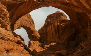
Double Arch, Arches National Monument Ashley National Forest
” The Ashley National Forest, with headquarters in Vernal, Utah, comprises 1.3 million acres located in the northeastern portion of Utah and southwestern portion of Wyoming. National Forest System lands are located in three major areas: the northern and southern slopes of the Uinta Mountains, the Wyoming Basin, and the Tavaputs Plateau.” The Forest is mostly in northeastern Utah, with just a bit including the Flaming Gorge in Wyoming.
Here is the Forest website. Phone 435-789-1181 Visitor Guide
 Yellowpine Interpretive trail 0.5 miles The trail is at the Yellowpine Campground.
Flaming Gorge National Recreation Area “The Flaming Gorge NRA is located in the northeast corner of Utah and the southwest corner of Wyoming.”
 Ryan, from flaminggorgecountry.com writes that “There are wheel chair accessible nature trails located at Moose Pond, West Green’s Lake, and Red Canyon overlook/Red Canyon Visitor center. Sheep Creek Geological loop, Sheep Creek Bay overlook, Red Canyon overlook, Dowd mountain overlook, Flaming Gorge Dam Visitor Center, and the Dam Vista Overlook are all easy access by vehicle with easy access viewpoints.”
Red Canyon Visitor Center 435-889-3713 ? The Chamber of Commerce Guide lists six “easy” trails on page 29. Be sure to call either the Visitor Center or the Chamber of Commerce since no details are given. From the website: “Try the short interpretive Nature Trails at Sheep Creek, Moose Ponds, West Greens Lake and Aspen for an easy enlightening walk through a variety of habitats along this scenic drive.” Easy for them might not be easy for you. Check with them.
Bear River Migratory Bird Refuge
“…Bear River MBR contains nearly 80,000 acres of marsh, open water, uplands, and alkali mudflats.” “Birds come to the Refuge by the millions to eat and rest during migration, and many other species stay to breed, nest and raise their young across the Refuge wetlands.”
Here is the Refuge website. Phone 435-723-5887 Hunting & Fishing brochure with map facebook page
 Marsh Meander trail 1.5 mile unpaved trail through the wetland habitat just outside the center.
 Wetland Walk is partially paved, and may be at least partly accessible but the website does not say so. AllTrails calls it a 0.6 mile loop.
Bryce Canyon National Park
Situated along a high plateau at the top of Utah’s Grand Staircase, Bryce Canyon’s high elevation includes the largest concentration of hoodoos (irregular columns of rock) on Earth, numerous life communities, and dark skies.
Here is the Park website. Phone 435-834-5322 Map and Guide
Accessibility Printable Access Guide
 Mossy Cave 0.8 mile Streamside walk to mossy grotto
 Rim Trail 11 miles total. Connects Bryce Point to Fairyland Point
 Sunset to Sunrise Points .5 mile each way. Paved portion of the Rim Trail
 Queen’s Garden 1.8 mile the “least difficult trail that descends into the Bryce Amphitheater. Elevation loss/gain is 357′.
 Bristlecone Loop 1.0 mile. Partly paved trail with elevation gain/loss of 200′ Wheelchair-accessible with assistance. Not entirely ADA compatible.
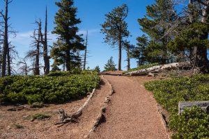
Accessible Bristle Cone Loop Trail, Bryce Canyon National Park UT 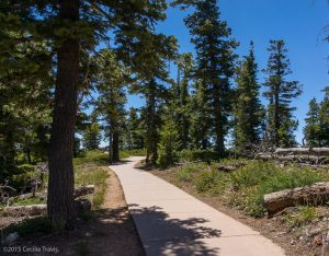
Paved part of the wheelchair-accessible Bristle Cone Loop Trail, Bryce Canyon National Park UT 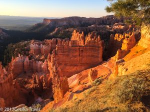
Bryce Canyon National Park, Utah photographed from wheelchair accessible paved trail Capitol Reef National Park –
“Located in south-central Utah in the heart of red rock country, Capitol Reef National Park is a hidden treasure filled with cliffs, canyons, domes, and bridges in the Waterpocket Fold, a geologic monocline (a wrinkle on the earth) extending almost 100 miles.”
For easy walking, we loved the canyon floors at Capitol Reef. These sand and gravel surfaces would bog down a wheelchair, but we did meet one intrepid wheelchair user who was enjoying the spectacular beauty from the paved roads. You can arrange for a driver to take you into the beautiful Cathedral Valley. My photographers and writers club, Rocky Mountain Outdoor Writers and Photographers, used Hondoo Rivers and Trails in Torrey. This park is not as crowded as many of the better known national parks in the west.
Here is the Park website. Phone 435-425-3791 Map Accessibility Brochure
 The petroglyphs along Utah Highway 24 are accessible by boardwalk.
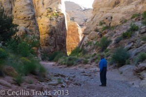
Canyon floor, Capitol Reef National Park 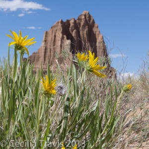
Cathedral Valley, Capitol Reef National Park Dinosaur National Monument
Dinosaur National Monument has one wheelchair accessible trail and numerous easy trails. The monument lies on the border between Colorado and Utah at the confluence of the Green and Yampa Rivers. just to the north of the town of Vernal, Utah. There are over 800 paleontological sites in the Jurassic Morrison formation. There are fossils of many dinosaurs including Allosaurus, Deinonychus, and Abydosaurus. Dinosaur National Monument protects 105 miles of the Green and Yampa rivers and more than 210,000 acres of the rivers’ canyons.
Phone 435-781-7700 Map Accessibility Links to trail details Monument website
 Plug Hat Trail 0.25 mile loop paved “…trail on top of a butte affords excellent views of the surrounding landscape and provides an introduction to the pinyon pine-juniper community.”
 Cold Desert Trail 0.5 mile loop “This short, level walk provides insight into the diversity of the desert shrub community found around Dinosaur National Monument.”
 Box Canyon Trail 0.5 mile in and out. “A level walk into a shady box canyon.”
 Gates of Lodore Trail 0.75 mile one way. There are a “few steps” at the beginning of the trail and then it is a level walk above the Green River ending at a view of the entrance to Lodore Canyon.
 Hog Canyon Trail 1.5 mile one way. “A relatively level walk into a box canyon.”
Dixie National Forest
The almost 2,000,000 acres of Dixie National Forest stretch for about 170 miles across southern Utah. The forest includes Red Canyon and Hell’s Backbone Bridge. There are many opportunities for “hiking, fishing, and viewing outstanding scenery.”
Here is the Forest website. Phone 801-466-6411 Maps
Red Canyon Powell Ranger District Visitor Center Phone 435-676-2676 Trails Map and Descriptions The map omits the easy Hoodoo Trail. Red Canyon is a lovely place near Bryce National Park, but without the crowds.
 Hoodoo Trail #3011 0.3 mile “Walk under the hoodoos, through sagebrush, pinyon, and juniper trees.”
 Pink Ledges Interpretive Trail 0.4 miles This trail is a bit more difficult than the Hoodoo, so you may just want to go for part of it and then turn around if you don’t like the slope.
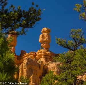
Hoodoo above Red Canyon, Dixie National Forest, Utah Easy hiking trail 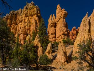
Pink Ledges Trail, Red Canyon, Dixie National Forest Utah Sawtooth National Forest / Sawtooth National Recreation Area
This 2.1 million acre forest is situated in south central Idaho and extends into northern Utah. It includes the 217,000 acre Sawtooth Wilderness. These lands include high granite peaks, narrow glacial valleys, deep forested valleys and high alpine lakes. It abounds with wildlife and flowers. Map of SNRA
Fairfield Ranger District 208-764-3202, Ketchum Ranger District 208-622-5371
Minidoka ranger district 208-677-4878, Sawtooth NRA 208-727-5000 or 208-744-3000 Here is the website for the National Forest and the website for the National Recreation Area. Murdock Trail Map and information A little over the first mile is wheelchair accessible. From the guide, “The Murdock Creek canyon features wildflowers, wildlife, and dramatic rock outcroppings, and there are several nice picnic spot along the trail.” The trail is dirt with small rocks. Thanks to trail guidebooks author Maryann Gaug for letting me know about this trail.
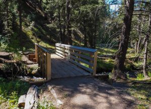
Accessible Stream Crossing on Murdock Creek Trail Sawtooth Nat’l. Forest, ID ©Maryann Gaug 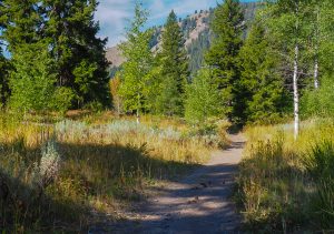
Partly accessible Murdock Creek Trail Sawtooth Nat’l. Forest, ID ©Maryann Gaug Uinta-Wasatch-Cache National Forest
“The Uinta-Wasatch-Cache National Forest is one of the 12 National Forests in the Intermountain Region as well as one of the urban National Forests in the Forest Service System. It covers an area that includes northern and north-central Utah, and southwestern Wyoming.”
Here is the Forest website. Supervisor phone 801-999-2103 Contacts in the various ranger districts.There is a video on the website describing 5 Family Friendly Trails which they say are good for strollers and people of all ages. At one point the voice-over claims they are “universally accessible”, but that is not clear from the photographs or the descriptions on the website.
 ? Limber Pine Nature Trail 1.4 miles
 ? Cascades springs interpretive trail 0.9 mile paved and boardwalk path
 Devils Kitchen Trail to a geologic site 0.1 mile “Accessible”
 ? Current Creek Nature Trail 1.25 miles self-guided interpretive trail. Call 435-654-0470 for more information on this trail.
 “Summer Lake Nature Trail 3/4 mile around a lake
Zion National Park
Located at the junction of the Colorado Plateau, Great Basin, and Mojave Desert regions, the Zion has a unique geography and a variety of life zones. The Virgin River flows through the 15 mile long Zion Canyon’s towering red and tan walls.
Here is the Park website. Phone 435-772-3256 Accessibility Map and Brochure Hiking Map and Guide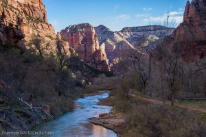
Accessible Riverside Walk, Zion National Park UT  Pa’rus Trail 3.5 miles “Paved trail follows the Virgin River from the South Campground to Canyon Junction.”
 Riverside Walk 2.2 miles. “Minor drop-offs. Paved trail follows the Virgin River along the bottom of a narrow canyon. Trailside exhibits.”
 Lower Emerald Pool Trail 1 mile paved with some minor drop-offs.
 Grotto Trail 1.2 mile connects the Zion Lodge to the Grotto and is near the road most of the way.
State
Antelope Island State Park
The park offers “spectacular views of lake and island scenery.” There are sandy beaches and you can “…take a dip in the lake’s salty waters or step back in time with a visit to the Historic Fielding Garr Ranch. Antelope Island is home to free-ranging bison, mule deer, bighorn sheep, pronghorn (antelope), and many other desert animals. Millions of birds congregate along the shores surrounding the island…”
Here is the Park website. Trails Map Brochure Utah Travel Secrets trail guide
Headquarters phone 801-649-5742, Visitor Center Phone 801-725-9263
 Lakeside Trail 2.8 miles one way. “An easy hike” that “follows a nicely maintained gravel path” with elevation gain of only 69′.
 Mountain View Trail is 11.38 miles one way and can be accessed via four parking areas. It follows the east shore of the island. “Wetlands and wildlife are abundant on the trail.”
Dead Horse Point State Park
“From the prominence of Dead Horse Point, 2,000 feet above a gooseneck in the Colorado River, an ever-changing landscape unfurls. Immense vertical cliffs meet with canyons carved by ice, water, and wind creating a visual masterpiece.”
Here is the Park website. Visitor Center phone 435-259-2614 Map Trail Map
Brochure Hiking
 Overlook Trail 200′ one way. “…a short paved pathway leads to breathtaking views of the Colorado River and adjacent canyon country some 2,000 feet below.”
 Visitor Center Trail 1/8 mile round trip. “The paved path just outside the Visitor Center offers great views of the basin to the east, the La Sal Mountains and Chimney Rock.” There are eight trail-side exhibits.
 The East Rim Trail System 1.5-2 miles “Aside from a short hill a quarter mile from the visitor center, this trail is predominately flat. ”
 The Colorado River Overlook 1 mile.
Fremont Indian State Park
Discover artifacts, petroglyphs, and pictographs left behind by the Fremont Indians. This museum preserves treasures from the largest known Fremont Indian village site. “Hike on paths that lead you up close to Rock art panels left by the Fremont people. “
Here is the Park website. Phone 4335-527-4631 Brochure
 Parade of Rock Art 0.4 miles paved interpretive trail
Historic Union Pacific Rail Trail
“Weaving its way from Park City to Echo Reservoir, this 28-mile, non-motorized trail provides a close-up view of area wildlife and wildflowers.”
Here is the Trail website. Phone 435-649-6839 Map
 This rail trail is 28 miles following interstate 80 from Park City to Echo Reservoir. It is mostly gravel, but there are 3 miles north from Park City and a 0.5 section in Wanship that are asphalt and suitable for wheelchairs. TrailLink’s description
Kodachrome Basin State Park
“67 monolithic stone spires, called sedimentary pipes, accentuate multihued sandstone layers that reveal 180 million years of geologic time. The color and beauty found here prompted a National Geographic Society expedition to name the area Kodachrome…”
Here is the Park website. Phone 435-679-8562 Brochure & Trails Map
 Grand Parade Trail 1.5 miles is easy, but check first to be sure it is suitable for you.
 Nature Trail 0.5 miles hard surface interpretive trail.
Robert N. Hasenyager Great Salt Lake Nature Reserve
The Reserve is located along the southeast shore of the Great Salt Lake, adjacent to the Utah Division of Wildlife Resources’ Farmington Bay Waterfowl Management Area (WMA). The new (2019) George S. and Dolores Doré Eccles Wildlife Education Center at Farmington Bay is on the Reserve. The Center and trails provide “…. a gateway to the remarkable Great Salt Lake wetlands. ”
Here is the Eccles Center website. Phone 801-451-5536.
 Farmington Creek Trail 1.5 miles ADA compliant. The “trail loops through the wetlands of Farmington Bay with several side trails. The trail features a 1700-foot-long boardwalk with a bridge over Farmington Creek, a long bridge across a large pond, and a winding boardwalk through a delightful marsh filled with birds of many kinds.”
Snow Canyon State Park
“Explore the trails and dunes of beautiful Snow Canyon ….. Camp in the peaceful campground surrounded by ancient lava flows and red Navajo sandstone.”
Here is the Park website. Brochure & Trail Map Overview Map Phone 435-628-2255
 Whiptail Trail 6 miles. “Level with some slopes. Accessible to people with disabilities. Tucked along the canyon bottom, this paved trail is suitable for walking, jogging, and biking.”
 Jenny’s Canyon 0.5 mile, Johnson Canyon 2 miles, Pioneer Names 0.5 mile, West Canyon Road 8 miles, and Sand Dunes 0.5 mile are trails rated as easy with some slopes and/or steps. Check with the Visitor Center to see if some of them would work for you.
Swaner EcoCenter
“The Swaner Preserve and EcoCenter is a 1,200 acre nature Preserve ….with interactive exhibits about the surrounding environment. … Visit the EcoCenter to learn more about our wetland ecosystem and the 10 miles of trails to explore!”
Here is the Center website. Utah State University 435-649-1767 Preserve and Trails
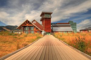
 Leslie, who answered my inquiry (and provided the photos) writes, “The EcoCenter and the pier going out onto the preserve are wheelchair accessible. However, in the winter the pier is covered with snow for snowshoeing. I would say summer and fall would be the best times for elderly and people with wheelchairs to visit.”
© Swaner EcoCenter 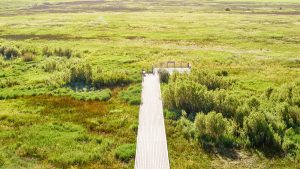
Wheelchair accessible walking pier path Swaner EcoCenter, Utah State University© Swaner EcoCenter
Local
Private
Ogden Nature Center
This 152-acre nature preserve and education center is open to the public year-round offering a wide variety of activities. “The center has limited paved paths. The rest of the center is leveled dirt trails.” Call to learn if any of these trails will accommodate your wheelchair.
Here is the Center’s website. Phone 801-621-7595 Map Virtual Tour
 There are 1.5 miles of “easy walking trails and paths. Most are dirt trails, and a few are paved…”
Miscellaneous
10 Stroller Friendly Trails in Utah by “Utah’s Adventure Family” is part of their very helpful website for families. You should also check out their page on Nature Trails.
12 Wheelchair Accessible Trails in Utah is a page on wanderookie.com, an excellent source of information on “Utah hikes and outdoor recreation for rookie adventurers”.
The Rails-to-Trails Conservancy lists wheelchair accessible trails in Utah.
Wheelchairtraveling.com is an outstanding resource.