Nevada has a number of trails with minimal obstacles. Some are very easy and others are wheelchair accessible. Here are just a few of them.
Most of the links given were found through Internet search. Some places I have been able to visit and a few have been recommended to me by other people who have been there. With your help, we can share our knowledge with disabled people everywhere and also increase awareness of the need for more accessibility. Please e-mail me with your suggestions using the form in the sidebar.
Federal
State
Local
Private
Miscellaneous
Federal
Ash Meadows National Wildlife Refuge
Here is the Refuge website. Brochure Map
“Year-round hiking is permitted along designated refuge roads and trails. Refuge boardwalks provide an up-close view of the springs, fish, and plants of Ash Meadows without disturbing the fragile habitat.”
 ? The photos of the boardwalks look as if they are wheelchair accessible, but you had better call 775 372-5435 to be sure.
Desert National Wildlife Refuge
“Encompassing six major mountain ranges and seven distinct life zones, Desert NWR showcases the abundance and variety of nature that can be found in Southern Nevada, all just a short drive from Las Vegas.”
Map Here is the Refuge website. Phone 1-702-879-6110 (the 1 is required)
Corn Creek Trail System Note: This trail is being repaired (2019) and is not currently accessible. Call to learn current conditions. Map the Bighorn (0.4 mile) , Jack Rabbit ( 0.1 mile) and Coyote (0.3 mile) loops are all accessible. Whispering Ben (0.1 mile) is rated easy. The Corn Creek Field Station ….”can be reached by traveling north on U.S. Highway 95 approximately 25 miles from downtown Las Vegas”.Lake Mead National Recreation Area
“With striking landscapes and brilliant blue waters, this year-round playground spreads across 1.5 million acres of mountains, canyons, valleys and two vast lakes. See the Hoover Dam from the waters of Lake Mead or Lake Mohave, or find solitude in one of the park’s nine wilderness areas.”
Here is the Area’s website. Page of links to maps. Accessibility Call 702-293-8990 for information.
River Mountains Loop Trail 35.3 miles from Boulder City to Henderson. As described on TrailLink “The surrounding River Mountains are home to one of the largest bighorn sheep populations in Nevada”.
? Historic Railroad Trail 3.7 miles from trailhead to Hoover Dam Parking Garage. “The Historic Railroad Trail is easily accessed either near the Alan Bible Visitor Center or via the Hoover Dam parking garage. It is an easy hike and has great panoramic views of Lake Mead, Boulder Basin, and Fortification Hill.” Soft sand may be a problem in places. Tunnel #3 is closed.
 ? Bluffs Trail Jim Boone of birdandhike.com describes this trail as ” a nice, relaxing, 0.9-mile stroll across the desert to a low summit overlooking all of the surrounding territory.” Judging from this youtube video of the trail by bigs2020, you would be wise to have trekking poles for balance. There are some pretty rocky stretches.
Moapa Valley National Wildlife Refuge.
Moapa Valley National Wildlife Refuge (NWR) is part of the Desert National Wildlife Refuge Complex. “The unique geology of the Moapa Valley National Wildlife Refuge makes it an important location for native wildlife. There are five major thermal springs in Moapa valley, three of which are located within refuge boundaries. The warm springs habitat supports many unique species.”
Here is the Refuge website. Brochure Call 702-515-5225 for information and hours. The refuge is closed during the summer. Satellite view map
A 0.5 mile loop trail provides interpretive information.Oxbow Nature Study Area
“Oxbow Nature Study Area is located on the Truckee River, one mile from downtown Reno. This site serves the public as the State of Nevada model for Wildlife Education and Aquatic Education programs offered by the Nevada Department of Wildlife.”
Here is the Area’s website. Phone 775-334-3808
Described by the Lahontan Audubon Society:
“Oxbow Nature Study Area is one of the few relatively intact riparian areas along the Truckee River in Reno. It is characterized by mature cottonwoods, Russian olive trees, willows, dense brush piles, and a small pond with thick cattails. A [one third mile] wheelchair-accessible boardwalk begins near the Interpretive Center.” Reviewed on Yelp, AllTrails.Pahranagat National Wildlife Refuge
” Pahranagat NWR’s lakes, marshes, wet meadows and tall cottonwood trees are a stunning contrast to the surrounding desert.” “Five habitat types located within the refuge’s 5,382 acres provide for a stunning array of flora and fauna.” Brochure Map Here is the Refuge website. Phone 775-725-3417 or 702-515-5450.
 Pahranagat Lake (upper) spillway walk is a 0.6 mile round trip loop as described by AllTrails as “Good for all skill levels.”
? Pahranagat Lake Upper Loop. LocalHikes.com describes this as 4.83 miles and easy, but with some “difficult spots”. Try calling to find out how much of the trail is truly easy.
Information provided by staff: “One ADA trail near the visitor center that is about 200 yrd long. One ADA ramp down to a marsh area and a short wood deck. However, the parking there is not ADA.” Try calling Tim Parker at 775-725-3417 ext. 101 for more information.Red Rock Canyon National Conservation Area
Red Rock Canyon, 17 miles west of the Las Vegas Strip, offers “… a 13-mile scenic drive, miles of hiking trails, rock climbing, horseback riding, mountain biking, road biking, picnic areas, nature observing and visitor center…”
Here is the Area’s website. Phone 702-515-5350 Accessibility
Trails described by the Red Rock Canyon Interpretive Association Trails described in Bird and Hike.com Map of Day Hikes
The 0.25 mile round trip Overlook trail goes to a view of the Canyon.Red Spring Boardwalk trail in Calico Canyon is a 1/2 mile boardwalk loop which “starts in a picnic area, switchbacks gently up a hillside beneath towering Velvet Ash trees, and then makes a wide loop around an alkali meadow to Red Spring, which is at the far side of the meadow from the top of the hillside. Shaded benches provide pleasant places to watch swallows flying over the meadows…”) Map and illustrations by Bird and Hike.com
Moenkopi Loop is a 2 mile loop which “…starts at the visitor center and traverses a prominent limestone ridge.” There are “panoramic views of the Wilson Cliffs..”
Lost Creek- Children’s Discovery is a 3/4 mile self-guided interpretive trail rated as easy.Fire Ecology Trail is an easy 3/4 mile loop through a 1997 prescribed burn area.Toiyabe-Humboldt National Forest
“The Humboldt-Toiyabe National Forest’s spectacular 6.3 million acres makes it the largest national forest in the lower 48 states. Located in Nevada and a small portion of eastern California, the Forest offers year-round recreation of all types.”
Carson Ranger District For maps and literature about the district, you can call Lindsay Pulliam at 775-882-2766. Here is the Forest website.
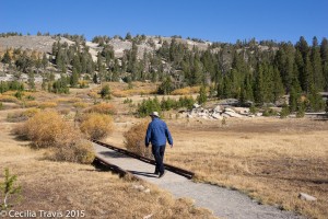
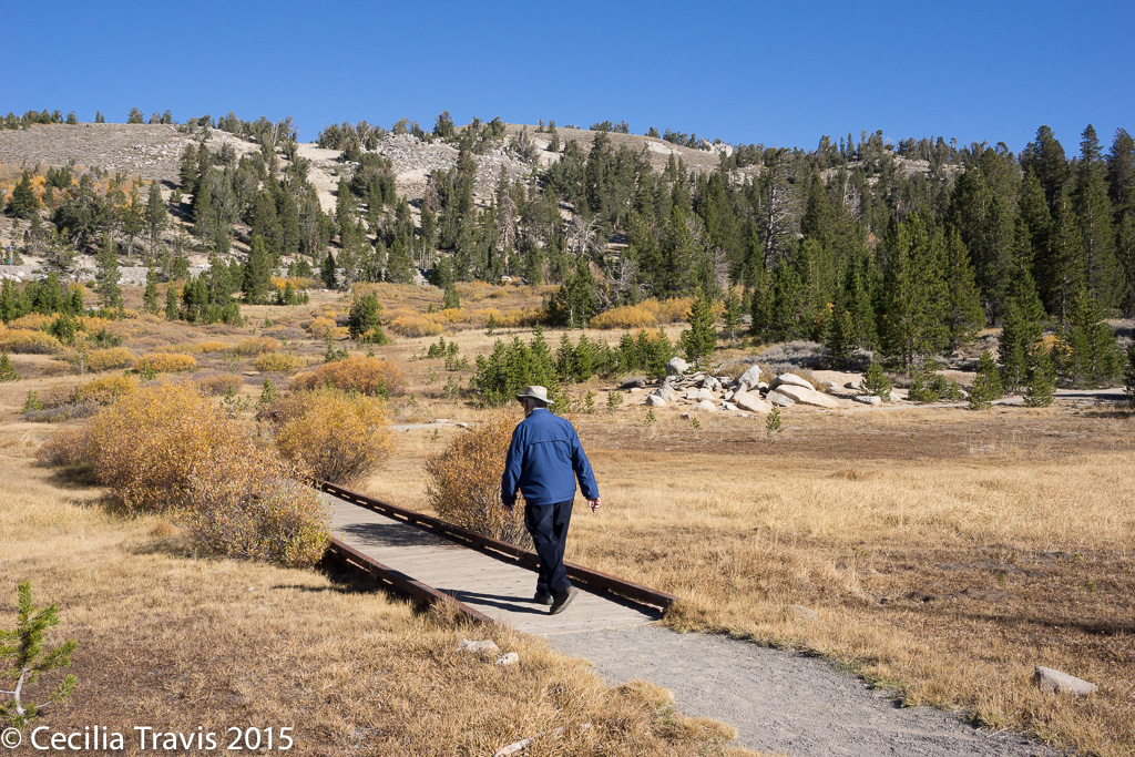
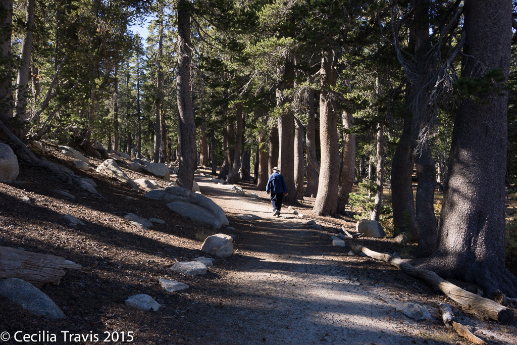
Accessible Tahoe Meadows Trail 
Accessible Tahoe Meadows Trail Tahoe Meadows Trail is a 1.2 mile loop off the Mount Rose Highway. No flowers when we were there in October, but pretty anyway. Elevation is about 9000′.Genoa Trail system includes two easy hikes at the Nature Conservancy’s River Ranch: “…The East Brockliss Loop is a 0.7 mile, nearly flat, natural surface trail with two short 24” wide boardwalks over water part of spring.”
The West Fork Trail is a 2-mile long, flat and wide trail also used occasionally as a ranch road that connects Genoa Lane and Muller Lane.” From Jeremy Vican, VP Trail Operations, “This on the River Fork Ranch Nature Conservancy property, a part of the Genoa Trail System most easily accessed from Genoa Lane.”
Genoa Vista Trail as described by the Carson Valley Trails Association, ” This is an approximate 1.3-mile ..trail between the town of Genoa and David Walley’s Hot Spring Resort.” and is fully paved in the town of Genoa.
From Jeremy Vican:
Fay-Luther Trail system. “The interpretive trail on Fay-Luther Trail System [BLM description] is the most accessible trail on that system. It is an interpretive loop, definitely not wheelchair accessible because of sandy soils, but easily doable for children and elderly.”
“Clear Creek Trail is a gentle grade…,not wheelchair accessible though.”“Bently-Kirman Tract Trail is flat, but a natural trail with cattle present, so not wheelchair friendly but very easy to do by most anyone else.”
State
Nevada State Parks home page. A List of all the Nevada State Parks with links to their websites.
“Individuals with developmental and/or physical limitations are invited to enjoy all of the recreational activities of Nevada State Parks. If you would like to request additional support or accommodation, please call the park system headquarters at (775) 684-2793.”Cathedral Gorge State Park
“Cathedral Gorge State Park is located in a long, narrow valley in southeastern Nevada, where erosion has carved dramatic and unique patterns in the soft bentonite clay.”Here is the Park website. Phone 775-728-4460 Trail map
Nature Loop is one mile. The Park Service states that “Bridge may impede wheelchair use.” You might want to call them for clarification.
Juniper Draw is 4 miles in a dry wash, described as easy with negligible altitude gain.
Eagle View Overlook is a 1/2 mile path with negligible altitude gain. “Overlook of entire Gorge; nature loop at beginning has interpretive signs.”
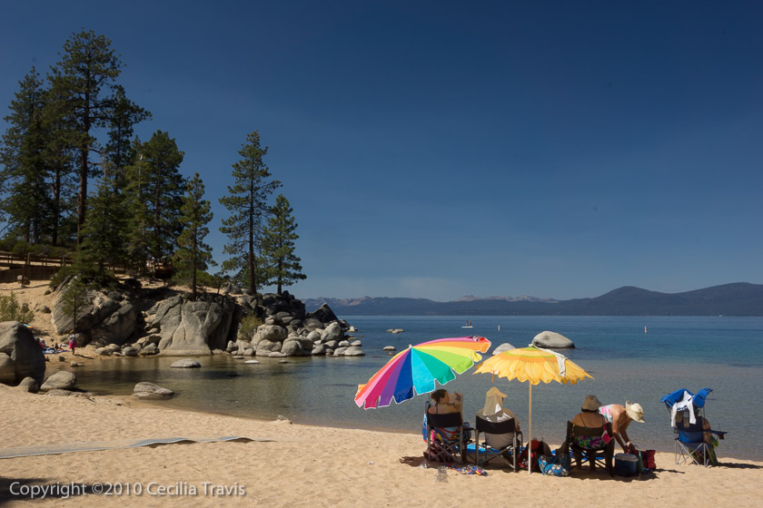
Swimmers at Sand Harbor – Lake Tahoe Nevada State Park NV Lake Tahoe Nevada State Park – Sand Harbor
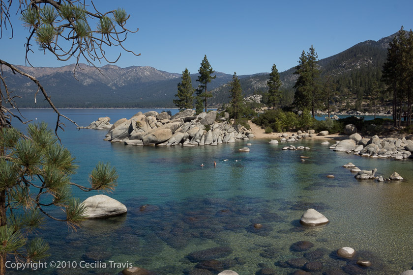
“The largest alpine lake in North America, Lake Tahoe is a cobalt blue lake atop the Sierra Nevada mountain range. On its eastern shores, gently sloping beaches, crystal-clear water and interesting rock formations allow for wonderfully sublime swimming, kayaking and scuba diving at Sand Harbor.”
Here is the Park website. Phone 775-831-0494 More informationThere are a 1/3 mile wheelchair accessible boardwalk nature trail and a picnic area here as well as an accessible path to a sandy beach. Even better, you can borrow one of their two beach wheelchairs, free of charge. The wheelchairs are available on a first-come-first-served basis. Entry to the park is $12 per car for non-residents of Nevada, but it’s worth it.

Accessible Beach Mat on Lake Tahoe, Sand Harbor – Lake Tahoe Nevada State Park NV 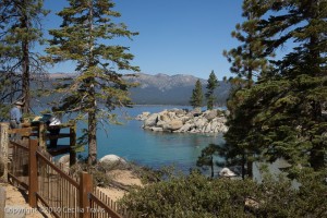
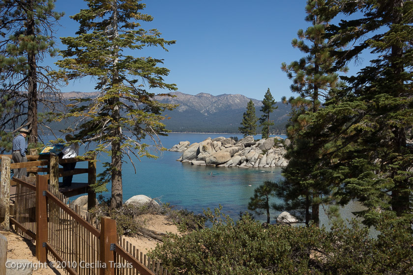
View from accessible Nature Trail, Sand Harbor – Lake Tahoe Nevada State Park NV 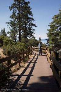
Accessible interpretive trail at Sand Harbor – Lake Tahoe Nevada State Park NV Spooner Backcountry in the Lake Tahoe Basin “…is a widespread recreational and natural oasis, with a lake surrounded by aspens and more than 12,000 acres of forested, open space. The park features 50 miles of hiking, equestrian and mountain biking trails and primitive roads. “
The Spooner Lake loop trail described by Tahoe Adventure Sports. Said to be “good for all skill levels” by AllTrails. These two references disagree on length — 2.1 or 1.8 miles.Spring Mountain Ranch State Park
Spring Mountain Ranch State Park, adjacent to the Red Rock Canyon National Conservation Area, “…has been used historically as a working ranch and a luxury retreat by a string of colorful owners, including German actress Vera Krupp and millionaire Howard Hughes. Today visitors can explore some of the oldest buildings in Nevada, a 1860s blacksmith shop, the Sandstone Cabin that was home to the founding family and the ranch house. Hiking trails throughout the park, in addition to tree-shaded picnic sites with tables and grills, make day trips to the park a family favorite. ” Thank you David Low, for your help.
Here is the Park website. Trail map.
? Two of the trails, 0.4 mile Lake Harriet and 0.3 mile North Ash Grove have crushed gravel or aggregate surfaces. Although both have low average gradients, each has a relatively steep stretch might make them too difficult. Call 702-875-4141 to inquire abut their suitability for you.Valley of Fire State Park
58 miles from Las Vegas, Valley of Fire State Park is 40,000 acres of bright red Aztec sandstone outcrops nestled in gray and tan limestone. There are “…ancient, petrified trees and petroglyphs dating back more than 2,000 years. A Visitor Center provides exhibits on the geology, ecology, prehistory and history of the park and nearby region. ”
Here is the Park website. Telephone 702-397-2088 Facebook Trail Map with surface and slope details
According to Planetware.com “Mouse’s Tank is an easy but exceptionally entertaining, .75-mile out-and-back hike along a sandy trail through a canyon. The trail is flat, with essentially no elevation gain, if you stick to the path, and it dead ends at the Mouse’s Tank; a natural water catchment…” The park’s trail guide claims that this trail has a 71′ stretch with a maximum grade of 21 to 31%. Check with the Visitor Center.Washoe Lake State Park
Situated between Reno and Carson City, Washoe Lake State Park sits in a valley with views of the Sierra Nevada, Carson and Virginia mountain ranges. The park “…hosts a diverse range of birds and waterfowl, such as American white pelicans and Canada geese. Anglers can aim for channel and bullhead catfish, wipers, white bass and Sacramento Perch.”
Here is the Park website. Trail Map
The park has a number of mostly low-gradient sandy trails with short steeper stretches. Call (775) 687-4319 to learn more.
Equestrian Trails Page 35 of this Truckee Meadows area guide states that the 15 miles of equestrian trails north of the paved bike path are ADA accessible. I don’t see these trails on the park trail map.
Paved Bike Path runs 2.7 miles on asphalt and is 8 feet wide. It is not shown as wheelchair accessible in the park literature, so you had better check first. 775-687-4319.

Local
Clark County Wetlands Park Map
Wetlands Nature Preserve “Trails wind through 210 acres of varied habitat, including: tall trees, ponds and streams, mesquite woodland, and desert scrub” Map There are ADA compliant trails shown on the map.
Duck Creek “Accessible trails tall shrubs, grass, and small trees. ….. Trails are currently accessed from the cul-de-sac at the east end of Wetlands Park Lane (outside of the Nature Preserve parking lot).
Wetlands Park Loop Trail “…. circles the entire Wetlands Park, totaling 13 miles and connecting all of our trailheads.” Most of it is paved, but one part of the trail, “along the south side of the Las Vegas Wash …. is currently unpaved. Sections may be periodically impassible due to construction.” The loop trail connects with the River Mountains Trail.Las Vegas Parks and Recreation call 702-229‐6541
Floyd Lamb Park at Tule Springs is a 680 acre park described as “… a welcome oasis in the desert of northwest Las Vegas. With its wildlife, lush vegetation, lakes and views of the Sheep and Spring Mountain Ranges, Floyd Lamb is a natural park unique to the typical Las Vegas urban experience.” Vegas.com Rated in Yelp
Thank you to Lee Birch for this description: “Just north of central Las Vegas, this park has hard, wide, paved trails. Park offers fishing, 4 ponds, and horseback riding. Full outer loop is about 0.8 miles, with internal trails in and around the ponds. No steep slopes. Suitable for wheelchairs and mobility scooters.”
Phone 702-229-6297
1 mile paved trail loops around the pond. Described in AllTrails.comReno Parks and Recreation call 775-334-2262.
Huffaker Park Lookout Trail page 30. This compacted gravel trail in Huffaker Park “wraps around a pair of hills offering a view of the Truckee Meadows. Visitors can hike a .75-mile or a 1.6-mile loop….”
Oxbow Nature Study Area Trail page 56 “From the trail inside Oxbow Nature Study Area, visitors may see deer, wild rabbits, beaver, golden eagles, hawks, falcons, quail, several types of ducks, snakes, lizards, muskrats and other native species. The trail has multiple access points to the Truckee River.”
Virginia Lake Loop Trail page 34. A one mile loop around the lake.Sparks
There are 40+ parks in the Sparks area.
Here is Sparks’ website. Phone (775) 353-2376
Vista-Campello Loop Trail The 3 mile concrete loop “offers a look at a variety of trees, shrubs and native plants. Many birds, cottontail rabbits and even an occasional coyote call this trail home.”Washoe County
Parks and Open Space call (775) 823-6500 website
The following trails were found in the Truckee Meadows Field Guide.
Rah Rah Interpretive Trail page 38. This paved, half-mile “interpretive nature loop trail inside Golden Eagle Regional Park highlights the Native American and natural history of the Rah Rah range.”
Swan Lake Nature Study Area page 50 ..”features an unusually diverse population of birds, including swans. Boardwalks take visitors throughout the wetlands area. Hiking trails also are available to the lake shore.”
Private
Miscellaneous
The Falcon Guide “Best Easy Day Hikes Lake Tahoe” by Tracy Salcedo-Chourré is very helpful for pointing you to easy hikes.
Nevada Trail Maps.com has published this list of ADA compliant trails.
The Rails-to-Trails Conservancy lists wheelchair accessible trails in Nevada.
The Truckee Meadows Trails Guide 2016 is the source for many of my posts. The guide is about public trails around the Truckee Meadows and is a cooperative effort by Reno, Sparks and Washoe County. The link will take you to the top and you need to scroll down the the given page number.
Verdi Center is an 8 acre cooperative effort between Nevada Department of Wildlife, Washoe County Public Library System, Washoe County School District, and the Verdi Community.
? I am guessing about the ease of this half-mile nature trail. Trail brochure Call 775-345-8104 for confirmation of its ease and condition.